
Topografische Karte Indravati National Park
Interaktive Karte
Klicken Sie auf die Karte, um die Höhe anzuzeigen.
Über diese Karte
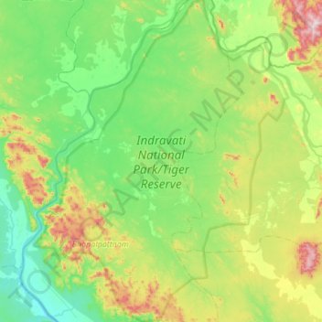
Name: Topografische Karte Indravati National Park, Höhe, Relief.
Durchschnittliche Höhe: 253 m
Minimale Höhe: 90 m
Maximale Höhe: 732 m
The topography of the park mainly comprises undulating hilly terrain with altitude ranging between 177 and 599 metres above the sea level.
Andere topografische Karten
Klicken Sie auf eine Karte, um ihre Topografie, ihre Höhe und ihr Relief anzuzeigen.
Bhairamgarh Tahsil
India > Chhattisgarh > Bijapur District
Bhairamgarh Tahsil, Bijapur District, Chhattisgarh, India
Durchschnittliche Höhe: 386 m