
Topografische Karte Stanford
Interaktive Karte
Klicken Sie auf die Karte, um die Höhe anzuzeigen.
Über diese Karte
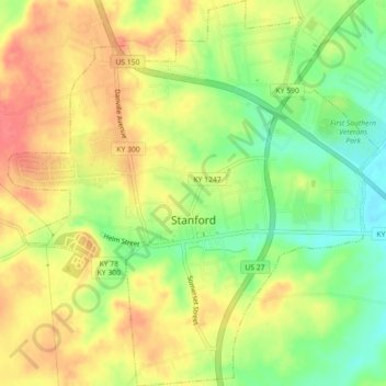
Name: Topografische Karte Stanford, Höhe, Relief.
Ort: Stanford, Lincoln County, Kentucky, United States (37.51584 -84.68342 37.55135 -84.64032)
Durchschnittliche Höhe: 292 m
Minimale Höhe: 258 m
Maximale Höhe: 319 m
Andere topografische Karten
Klicken Sie auf eine Karte, um ihre Topografie, ihre Höhe und ihr Relief anzuzeigen.
Hustonville
United States > Kentucky > Lincoln County
Hustonville, Lincoln County, Kentucky, United States
Durchschnittliche Höhe: 316 m
Kings Mountain
United States > Kentucky > Lincoln County
Kings Mountain, Lincoln County, Kentucky, 40442, United States
Durchschnittliche Höhe: 375 m
Blue Lick
United States > Kentucky > Lincoln County
Blue Lick, Lincoln County, Kentucky, 40484, United States
Durchschnittliche Höhe: 336 m
logan hubble park
United States > Kentucky > Lincoln County
logan hubble park, Lincoln County, Kentucky, United States
Durchschnittliche Höhe: 267 m
Crab Orchard
United States > Kentucky > Lincoln County
Crab Orchard, Lincoln County, Kentucky, United States
Durchschnittliche Höhe: 283 m