
Topografische Karte Walden
Interaktive Karte
Klicken Sie auf die Karte, um die Höhe anzuzeigen.
Über diese Karte
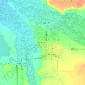
Name: Topografische Karte Walden, Höhe, Relief.
Ort: Walden, Jackson County, Colorado, United States (40.72605 -106.28693 40.73695 -106.27409)
Durchschnittliche Höhe: 2’463 m
Minimale Höhe: 2’447 m
Maximale Höhe: 2’490 m
Walden is the Statutory Town that is the county seat, the most populous community, and the only incorporated municipality in Jackson County, Colorado, United States. It is situated in the center of a large open valley called North Park. People from Walden and the surrounding area refer to themselves as "North Parkers". The town population was 606 at the 2020 census. The town sits at an elevation of 8,099 feet (2,469 meters). It was established in 1889 and was incorporated 2 December 1890. Mark A. Walden, an early postmaster, gave the community his name.
Andere topografische Karten
Klicken Sie auf eine Karte, um ihre Topografie, ihre Höhe und ihr Relief anzuzeigen.
Davis Peak
United States > Colorado > Jackson County
Davis Peak, Jackson County, Colorado, United States
Durchschnittliche Höhe: 3’246 m
Cowdrey
United States > Colorado > Jackson County
Cowdrey, Jackson County, Colorado, 80434, United States
Durchschnittliche Höhe: 2’413 m
Continental Divide
United States > Colorado > Jackson County
Continental Divide, Jackson County, Colorado, United States
Durchschnittliche Höhe: 3’403 m
Rand
United States > Colorado > Jackson County
Rand, Jackson County, Colorado, 80473, United States
Durchschnittliche Höhe: 2’631 m
Pitchpine Mountain
United States > Colorado > Jackson County
Pitchpine Mountain, Jackson County, Colorado, United States
Durchschnittliche Höhe: 2’553 m
Mount Zirkel
United States > Colorado > Jackson County
Mount Zirkel, Jackson County, Colorado, United States
Durchschnittliche Höhe: 3’359 m