
Topografische Karte Uslar
Interaktive Karte
Klicken Sie auf die Karte, um die Höhe anzuzeigen.
Über diese Karte
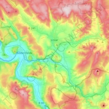
Name: Topografische Karte Uslar, Höhe, Relief.
Ort: Uslar, Landkreis Northeim, Lower Saxony, 37170, Germany (51.55120 9.52275 51.72102 9.76831)
Durchschnittliche Höhe: 269 m
Minimale Höhe: 99 m
Maximale Höhe: 499 m
Andere topografische Karten
Klicken Sie auf eine Karte, um ihre Topografie, ihre Höhe und ihr Relief anzuzeigen.
Bodenfelde
Germany > Lower Saxony > Landkreis Northeim
Bodenfelde, Landkreis Northeim, Lower Saxony, 37194, Germany
Durchschnittliche Höhe: 237 m
Dassel
Germany > Lower Saxony > Landkreis Northeim
Dassel, Landkreis Northeim, Lower Saxony, 37586, Germany
Durchschnittliche Höhe: 277 m
Clus
Germany > Lower Saxony > Landkreis Northeim > Bad Gandersheim
Clus, Bad Gandersheim, Landkreis Northeim, Lower Saxony, 37581, Germany
Durchschnittliche Höhe: 169 m
Balos
Germany > Lower Saxony > Landkreis Northeim > Moringen
Balos, Moringen, Landkreis Northeim, Lower Saxony, 37186, Germany
Durchschnittliche Höhe: 293 m