
Topografische Karte Camden
Interaktive Karte
Klicken Sie auf die Karte, um die Höhe anzuzeigen.
Über diese Karte
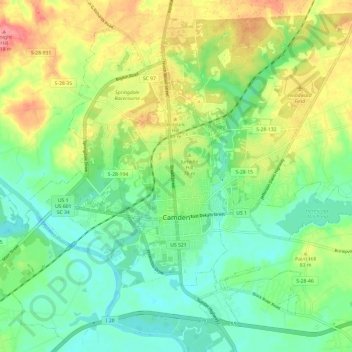
Name: Topografische Karte Camden, Höhe, Relief.
Ort: Camden, Kershaw County, South Carolina, United States (34.21628 -80.65768 34.30000 -80.53743)
Durchschnittliche Höhe: 68 m
Minimale Höhe: 35 m
Maximale Höhe: 123 m
Andere topografische Karten
Klicken Sie auf eine Karte, um ihre Topografie, ihre Höhe und ihr Relief anzuzeigen.
Kirkover Hills
United States > South Carolina > Kershaw County > Camden
Kirkover Hills, Camden, Kershaw County, South Carolina, 29020, United States
Durchschnittliche Höhe: 72 m
Elgin
United States > South Carolina > Kershaw County
Elgin, Kershaw County, South Carolina, United States
Durchschnittliche Höhe: 104 m
Sunnyhill
United States > South Carolina > Kershaw County > Camden > Sunnyhill
Sunnyhill, Camden, Kershaw County, South Carolina, 29020, United States
Durchschnittliche Höhe: 86 m
Lugoff
United States > South Carolina > Kershaw County
Lugoff, Kershaw County, South Carolina, United States
Durchschnittliche Höhe: 69 m