
Topografische Karte Vieux Bréhec
Interaktive Karte
Klicken Sie auf die Karte, um die Höhe anzuzeigen.
Über diese Karte
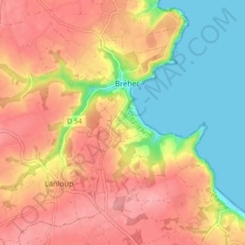
Name: Topografische Karte Vieux Bréhec, Höhe, Relief.
Durchschnittliche Höhe: 55 m
Minimale Höhe: 0 m
Maximale Höhe: 99 m
Andere topografische Karten
Klicken Sie auf eine Karte, um ihre Topografie, ihre Höhe und ihr Relief anzuzeigen.
Crec'h Huel
France > Bretagne > Côtes-d'Armor > Plouha
Crec'h Huel, Plouha, Guingamp, Côtes-d'Armor, Bretagne, France métropolitaine, 22580, France
Durchschnittliche Höhe: 83 m
Kerouziel
France > Bretagne > Côtes-d'Armor > Plouha
Kerouziel, Plouha, Guingamp, Côtes-d'Armor, Bretagne, France métropolitaine, 22580, France
Durchschnittliche Höhe: 38 m
Le Palus
France > Bretagne > Côtes-d'Armor > Plouha
Le Palus, Plouha, Guingamp, Côtes-d'Armor, Bretagne, France métropolitaine, 22580, France
Durchschnittliche Höhe: 49 m
Kerlevenez
France > Bretagne > Côtes-d'Armor > Plouha
Kerlevenez, Plouha, Guingamp, Côtes-d'Armor, Bretagne, France métropolitaine, 22580, France
Durchschnittliche Höhe: 62 m
Kerlévé
France > Bretagne > Côtes-d'Armor > Plouha
Kerlévé, Plouha, Guingamp, Côtes-d'Armor, Bretagne, France métropolitaine, 22580, France
Durchschnittliche Höhe: 82 m