
Topografische Karte North Stonington
Interaktive Karte
Klicken Sie auf die Karte, um die Höhe anzuzeigen.
Über diese Karte
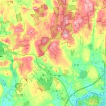
Name: Topografische Karte North Stonington, Höhe, Relief.
Durchschnittliche Höhe: 78 m
Minimale Höhe: 3 m
Maximale Höhe: 163 m
Andere topografische Karten
Klicken Sie auf eine Karte, um ihre Topografie, ihre Höhe und ihr Relief anzuzeigen.
Mashantucket
United States > Connecticut > New London County > Ledyard > Mashantucket
Mashantucket, Ledyard, New London County, Connecticut, United States
Durchschnittliche Höhe: 65 m
Colchester
United States > Connecticut > New London County > Colchester
Colchester, New London County, Connecticut, United States
Durchschnittliche Höhe: 132 m
Waterford
United States > Connecticut > New London County > Waterford
Waterford, New London County, Connecticut, 06385, United States
Durchschnittliche Höhe: 35 m
Sprague
United States > Connecticut > New London County > Sprague
Sprague, New London County, Connecticut, United States
Durchschnittliche Höhe: 77 m
Town Open Space (Roxbury & Romagna Roads)
United States > Connecticut > New London County > East Lyme > Niantic
Town Open Space (Roxbury & Romagna Roads), Niantic, East Lyme, New London County, Connecticut, United States
Durchschnittliche Höhe: 26 m
Griswold
United States > Connecticut > New London County > Griswold
Griswold, New London County, Connecticut, United States
Durchschnittliche Höhe: 70 m
Poquonock Bridge
United States > Connecticut > New London County > Groton > Poquonock Bridge
Poquonock Bridge, Groton, New London County, Connecticut, United States
Durchschnittliche Höhe: 15 m