
Topografische Karte Kejimkujik Lake
Interaktive Karte
Klicken Sie auf die Karte, um die Höhe anzuzeigen.
Über diese Karte
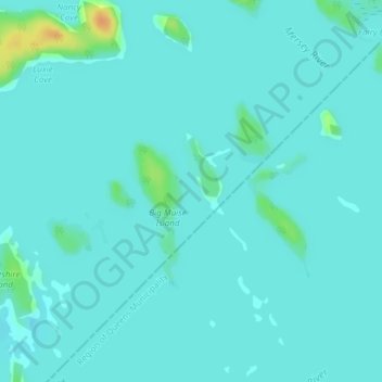
Name: Topografische Karte Kejimkujik Lake, Höhe, Relief.
Durchschnittliche Höhe: 89 m
Minimale Höhe: 84 m
Maximale Höhe: 118 m
Andere topografische Karten
Klicken Sie auf eine Karte, um ihre Topografie, ihre Höhe und ihr Relief anzuzeigen.
Kejimkujik National Park of Canada
Canada > Nova Scotia > Kejimkujik National Park of Canada
Kejimkujik National Park of Canada, Digby Municipal District, Digby County, Nova Scotia, B0T 1N0, Canada
Durchschnittliche Höhe: 145 m