
Topografische Karte Greenwood
Interaktive Karte
Klicken Sie auf die Karte, um die Höhe anzuzeigen.
Über diese Karte
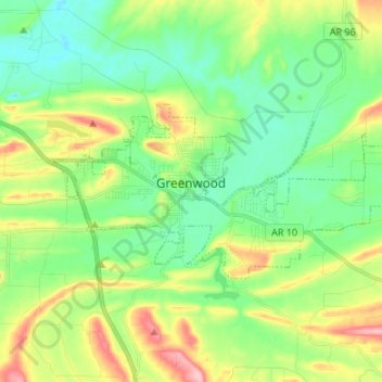
Name: Topografische Karte Greenwood, Höhe, Relief.
Ort: Greenwood, Sebastian County, Arkansas, 72936, United States (35.18924 -94.30636 35.23923 -94.17246)
Durchschnittliche Höhe: 179 m
Minimale Höhe: 128 m
Maximale Höhe: 284 m
Andere topografische Karten
Klicken Sie auf eine Karte, um ihre Topografie, ihre Höhe und ihr Relief anzuzeigen.
Hackett
United States > Arkansas > Sebastian County
Hackett, Sebastian County, Arkansas, United States
Durchschnittliche Höhe: 167 m
Barling
United States > Arkansas > Sebastian County
Barling, Sebastian County, Arkansas, 72923, United States
Durchschnittliche Höhe: 136 m
Lavaca
United States > Arkansas > Sebastian County
Lavaca, Sebastian County, Arkansas, 72941, United States
Durchschnittliche Höhe: 134 m
Fort Smith
United States > Arkansas > Sebastian County
Fort Smith, Sebastian County, Arkansas, United States
Durchschnittliche Höhe: 140 m
Fort Smith
United States > Arkansas > Sebastian County > Fort Smith
Fort Smith, Sebastian County, Arkansas, 72901, United States
Durchschnittliche Höhe: 163 m