
Topografische Karte Nagtipunan
Interaktive Karte
Klicken Sie auf die Karte, um die Höhe anzuzeigen.
Über diese Karte
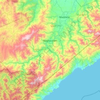
Name: Topografische Karte Nagtipunan, Höhe, Relief.
Ort: Nagtipunan, Quirino, Cagayan Valley, Philippines (15.94629 121.29528 16.39017 121.83782)
Durchschnittliche Höhe: 547 m
Minimale Höhe: 0 m
Maximale Höhe: 1’738 m
Andere topografische Karten
Klicken Sie auf eine Karte, um ihre Topografie, ihre Höhe und ihr Relief anzuzeigen.
Baguio Village
Philippines > Quirino > Diffun
Baguio Village, Diffun, Quirino, Cagayan Valley, Philippines
Durchschnittliche Höhe: 371 m
Dibibi
Philippines > Quirino > Cabarroguis
Dibibi, Cabarroguis, Quirino, Cagayan Valley, Philippines
Durchschnittliche Höhe: 238 m
Cabarroguis
Cabarroguis, Quirino, Cagayan Valley, 3400, Philippines
Durchschnittliche Höhe: 289 m
Saguday
Saguday, Quirino, Cagayan Valley, 3401, Philippines
Durchschnittliche Höhe: 112 m
San Marcos
San Marcos, Quirino, Cagayan Valley, 3401, Philippines
Durchschnittliche Höhe: 142 m
Aglipay
Philippines > Quirino > Aglipay
Aglipay, Quirino, Cagayan Valley, Philippines
Durchschnittliche Höhe: 142 m