
Topografische Karte Raynesford
Interaktive Karte
Klicken Sie auf die Karte, um die Höhe anzuzeigen.
Über diese Karte
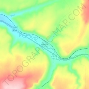
Name: Topografische Karte Raynesford, Höhe, Relief.
Durchschnittliche Höhe: 1’305 m
Minimale Höhe: 1’200 m
Maximale Höhe: 1’425 m
Raynesford is an unincorporated community in Judith Basin County, Montana, United States. Its elevation is 4,042 feet (1,232 m), and it is located at 47°16′12″N 110°43′48″W / 47.27000°N 110.73000°W / 47.27000; -110.73000 (47.2699643, -110.7299417). The community includes a community center, a catholic church, a fire department, and a post office. The post office was established under the name of "Spion Kop" on March 31, 1906; its name was changed to Raynesford exactly three years later.
Andere topografische Karten
Klicken Sie auf eine Karte, um ihre Topografie, ihre Höhe und ihr Relief anzuzeigen.
Stanford
United States > Montana > Judith Basin County
Stanford, Judith Basin County, Montana, 59579, United States
Durchschnittliche Höhe: 1’304 m