
Topografische Karte Germiston
Interaktive Karte
Klicken Sie auf die Karte, um die Höhe anzuzeigen.
Über diese Karte
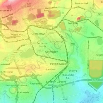
Name: Topografische Karte Germiston, Höhe, Relief.
Durchschnittliche Höhe: 1’635 m
Minimale Höhe: 1’549 m
Maximale Höhe: 1’760 m
Andere topografische Karten
Klicken Sie auf eine Karte, um ihre Topografie, ihre Höhe und ihr Relief anzuzeigen.
Nigel
South Africa > Gauteng > City of Ekurhuleni Metropolitan Municipality
Nigel, City of Ekurhuleni Metropolitan Municipality, Gauteng, 1491, South Africa
Durchschnittliche Höhe: 1’570 m
Alberton
South Africa > Gauteng > City of Ekurhuleni Metropolitan Municipality
Alberton, City of Ekurhuleni Metropolitan Municipality, Gauteng, 1449, South Africa
Durchschnittliche Höhe: 1’628 m
Tembisa
South Africa > Gauteng > City of Ekurhuleni Metropolitan Municipality
Tembisa, City of Ekurhuleni Metropolitan Municipality, Gauteng, 1632, South Africa
Durchschnittliche Höhe: 1’594 m
Kempton Park
South Africa > Gauteng > City of Ekurhuleni Metropolitan Municipality
Kempton Park, City of Ekurhuleni Metropolitan Municipality, Gauteng, 1619, South Africa
Durchschnittliche Höhe: 1’654 m
Benoni
South Africa > Gauteng > City of Ekurhuleni Metropolitan Municipality
Benoni, City of Ekurhuleni Metropolitan Municipality, Gauteng, 1500, South Africa
Durchschnittliche Höhe: 1’645 m