
Topografische Karte Frogholt
Klicken Sie auf die Karte, um die Höhe anzuzeigen.
Über diese Karte
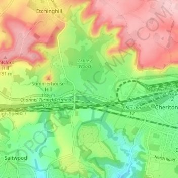
Name: Topografische Karte Frogholt, Höhe, Relief.
Durchschnittliche Höhe: 93 m
Minimale Höhe: 13 m
Maximale Höhe: 188 m
Andere topografische Karten
Klicken Sie auf eine Karte, um ihre Topografie, ihre Höhe und ihr Relief anzuzeigen.
Folkestone
United Kingdom > England > Kent > Folkestone and Hythe District
Durchschnittliche Höhe: 62 m
Hawkinge
United Kingdom > England > Kent > Folkestone and Hythe District
Durchschnittliche Höhe: 140 m
New Romney
United Kingdom > England > Kent > Folkestone and Hythe District
Durchschnittliche Höhe: 2 m
Stelling Minnis
United Kingdom > England > Kent > Folkestone and Hythe District
Durchschnittliche Höhe: 135 m
Sellindge
United Kingdom > England > Kent > Folkestone and Hythe District
Durchschnittliche Höhe: 71 m
Newington
United Kingdom > England > Kent > Folkestone and Hythe District
Durchschnittliche Höhe: 112 m
Postling
United Kingdom > England > Kent > Folkestone and Hythe District
Durchschnittliche Höhe: 112 m
Elmsted
United Kingdom > England > Kent > Folkestone and Hythe District > Lymbridge Green
Durchschnittliche Höhe: 144 m
Stowting
United Kingdom > England > Kent > Folkestone and Hythe District
Durchschnittliche Höhe: 148 m
Greatstone beach
United Kingdom > England > Kent > Folkestone and Hythe District > New Romney > Littlestone on Sea
Durchschnittliche Höhe: 2 m
Paddlesworth
United Kingdom > England > Kent > Folkestone and Hythe District
Durchschnittliche Höhe: 161 m
St. Mary in the Marsh
United Kingdom > England > Kent > Folkestone and Hythe District
Durchschnittliche Höhe: 2 m
Monks Horton
United Kingdom > England > Kent > Folkestone and Hythe District
Durchschnittliche Höhe: 104 m
Folkestone
United Kingdom > England > Kent > Folkestone and Hythe District
Durchschnittliche Höhe: 62 m
Folkestone
United Kingdom > England > Kent > Folkestone and Hythe District
Durchschnittliche Höhe: 62 m
Old Romney
United Kingdom > England > Kent > Folkestone and Hythe District
Durchschnittliche Höhe: 2 m
Folkestone
United Kingdom > England > Kent > Folkestone and Hythe District
Durchschnittliche Höhe: 62 m
Newington
United Kingdom > England > Kent > Folkestone and Hythe District
Durchschnittliche Höhe: 112 m
Folkestone
United Kingdom > England > Kent > Folkestone and Hythe District
Durchschnittliche Höhe: 62 m
Sellindge
United Kingdom > England > Kent > Folkestone and Hythe District
Durchschnittliche Höhe: 71 m
New Romney
United Kingdom > England > Kent > Folkestone and Hythe District
Durchschnittliche Höhe: 2 m
Folkestone
United Kingdom > England > Kent > Folkestone and Hythe District
Durchschnittliche Höhe: 62 m