
Spenden
Rüste dich für dein nächstes Abenteuer:
Als Amazon-Partner verdient diese Seite an qualifizierten Käufen, ohne dass Ihnen zusätzliche Kosten entstehen.
Topografische Karte North Potomac
Klicken Sie auf die Karte, um die Höhe anzuzeigen.
Spenden
Rüste dich für dein nächstes Abenteuer:
Als Amazon-Partner verdient diese Seite an qualifizierten Käufen, ohne dass Ihnen zusätzliche Kosten entstehen.
North Potomac
Between the 1990 and 2000 census, North Potomac gained and lost land. The loss was caused when a portion of the North Potomac territory, plus Potomac territory, was used to create the Travilah census designated place. According to the United States Census Bureau, North Potomac has a total area of 6.6 square miles (17 km2), virtually all land. The Muddy Branch and its tributary Rich Branch are streams that run through North Potomac, and the Muddy Branch empties into the Potomac River. The United States Geological Survey lists two features in Montgomery County with North Potomac in all or part of their name. The North Potomac Census Designated Place is listed with an elevation of 390 feet (120 m), while the North Potomac Populated Place has an elevation of 256 feet (78 m).
Spenden
Rüste dich für dein nächstes Abenteuer:
Als Amazon-Partner verdient diese Seite an qualifizierten Käufen, ohne dass Ihnen zusätzliche Kosten entstehen.
Über diese Karte
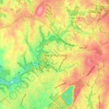
Name: Topografische Karte North Potomac, Höhe, Relief.
Ort: North Potomac, Montgomery County, Maryland, United States (39.07849 -77.26774 39.11850 -77.19406)
Durchschnittliche Höhe: 116 m
Minimale Höhe: 64 m
Maximale Höhe: 154 m
Spenden
Rüste dich für dein nächstes Abenteuer:
Als Amazon-Partner verdient diese Seite an qualifizierten Käufen, ohne dass Ihnen zusätzliche Kosten entstehen.