
Topografische Karte Chango
Klicken Sie auf die Karte, um die Höhe anzuzeigen.
Über diese Karte
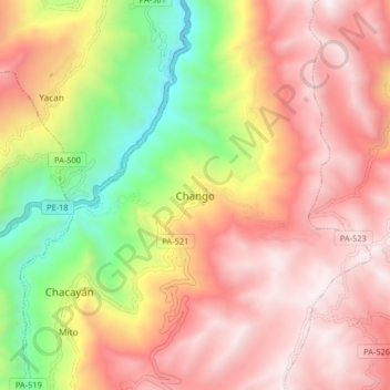
Name: Topografische Karte Chango, Höhe, Relief.
Ort: Chango, Chacayán, Province of Daniel Carrión, Pasco, Peru (-10.45451 -76.45126 -10.37451 -76.37126)
Durchschnittliche Höhe: 3’621 m
Minimale Höhe: 2’677 m
Maximale Höhe: 4’320 m
Andere topografische Karten
Klicken Sie auf eine Karte, um ihre Topografie, ihre Höhe und ihr Relief anzuzeigen.
Villa Rica
The District of Villa Rica is on the eastern slopes of the Andes mountains in an area of abundant rainfall and mild temperatures. It is located in the ecological zone of the Peruvian Yungas, or Ceja de Selva ("eyebrow of the jungle"), the transition zone between the low jungles of the Amazon Basin and the…
Durchschnittliche Höhe: 1’708 m
Province of Oxapampa
Oxapampa is the largest of three provinces that make up the Pasco Region in Peru. The capital of the province is the city of Oxapampa. The province is located on the eastern slopes of the Andes reaching down to the lowlands of the Amazon Basin. The high point of the province is approximately 5,300 metres…
Durchschnittliche Höhe: 1’348 m
Villa Rica
The District of Villa Rica is on the eastern slopes of the Andes mountains in an area of abundant rainfall and mild temperatures. It is located in the ecological zone of the Peruvian Yungas, or Ceja de Selva ("eyebrow of the jungle"), the transition zone between the low jungles of the Amazon Basin and the…
Durchschnittliche Höhe: 1’708 m