
Topografische Karte Hite Point
Interaktive Karte
Klicken Sie auf die Karte, um die Höhe anzuzeigen.
Über diese Karte
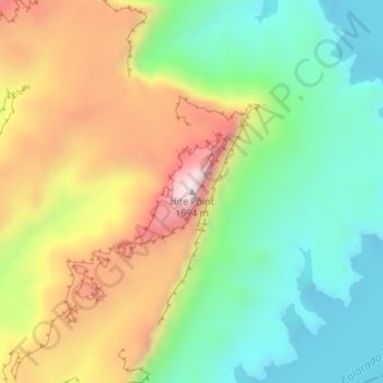
Name: Topografische Karte Hite Point, Höhe, Relief.
Ort: Hite Point, Garfield County, Utah, United States (37.85967 -110.42973 37.85977 -110.42963)
Durchschnittliche Höhe: 1’348 m
Minimale Höhe: 1’109 m
Maximale Höhe: 1’694 m
Andere topografische Karten
Klicken Sie auf eine Karte, um ihre Topografie, ihre Höhe und ihr Relief anzuzeigen.
Cannonville
United States > Utah > Garfield County
Cannonville, Garfield County, Utah, 84718, United States
Durchschnittliche Höhe: 1’894 m
Panguitch Lake
United States > Utah > Garfield County
Panguitch Lake, Garfield County, Utah, United States
Durchschnittliche Höhe: 2’528 m
Bryce Canyon National Park
United States > Utah > Garfield County
Bryce Canyon National Park, Garfield County, Utah, United States
Durchschnittliche Höhe: 2’259 m
Upper Calf Creek Fall
United States > Utah > Garfield County
Upper Calf Creek Fall, Garfield County, Utah, 84716, United States
Durchschnittliche Höhe: 1’904 m
Piracy Point
United States > Utah > Garfield County
Piracy Point, Bryce Canyon Scenic Drive, Garfield County, Utah, United States
Durchschnittliche Höhe: 2’551 m
Henderson Creek
United States > Utah > Garfield County
Henderson Creek, Garfield County, Utah, 84776, United States
Durchschnittliche Höhe: 2’017 m
Antimony
United States > Utah > Garfield County
Antimony, Garfield County, Utah, 84712, United States
Durchschnittliche Höhe: 2’061 m
Bryce Canyon
United States > Utah > Garfield County > Tropic
Bryce Canyon, Tropic, Garfield County, Utah, 84776, United States
Durchschnittliche Höhe: 2’247 m
Escalante
United States > Utah > Garfield County
Escalante, Garfield County, Utah, 84726, United States
Durchschnittliche Höhe: 1’781 m
Hatch
United States > Utah > Garfield County
Hatch, Garfield County, Utah, 84735, United States
Durchschnittliche Höhe: 2’135 m
Bryce Canyon City
United States > Utah > Garfield County > Bryce Canyon City
Bryce Canyon City, Garfield County, Utah, 84764, United States
Durchschnittliche Höhe: 2’337 m
Panguitch
United States > Utah > Garfield County > Panguitch
Panguitch, Garfield County, Utah, 87459, United States
Durchschnittliche Höhe: 2’081 m
Andy Miller Flats
United States > Utah > Garfield County
Andy Miller Flats, Garfield County, Utah, United States
Durchschnittliche Höhe: 1’604 m
Panguitch
United States > Utah > Garfield County
Panguitch, Garfield County, Utah, United States
Durchschnittliche Höhe: 2’043 m
Capitol Reef National Park
United States > Utah > Garfield County
Capitol Reef National Park, Garfield County, Utah, United States
Durchschnittliche Höhe: 1’963 m