
Spenden
Rüste dich für dein nächstes Abenteuer:
Als Amazon-Partner verdient diese Seite an qualifizierten Käufen, ohne dass Ihnen zusätzliche Kosten entstehen.
Topografische Karte Midland
Klicken Sie auf die Karte, um die Höhe anzuzeigen.
Spenden
Rüste dich für dein nächstes Abenteuer:
Als Amazon-Partner verdient diese Seite an qualifizierten Käufen, ohne dass Ihnen zusätzliche Kosten entstehen.
Über diese Karte
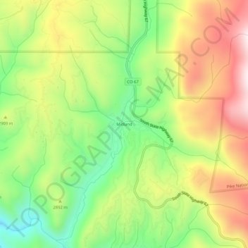
Name: Topografische Karte Midland, Höhe, Relief.
Ort: Midland, Teller County, Colorado, United States (38.83832 -105.18165 38.87832 -105.14165)
Durchschnittliche Höhe: 2’874 m
Minimale Höhe: 2’592 m
Maximale Höhe: 3’199 m
Spenden
Rüste dich für dein nächstes Abenteuer:
Als Amazon-Partner verdient diese Seite an qualifizierten Käufen, ohne dass Ihnen zusätzliche Kosten entstehen.
Andere topografische Karten
Klicken Sie auf eine Karte, um ihre Topografie, ihre Höhe und ihr Relief anzuzeigen.
Woodland Park
United States > Colorado > Teller County
The area is characterized by the abundance of large granite rocks and alpine meadows, as well as its consistently high elevation ranging between 8,200 and 10,000 feet above sea level. The climate is considered arid which causes the surrounding forests to become very dry, posing a significant fire threat in…
Durchschnittliche Höhe: 2’652 m
Cripple Creek
United States > Colorado > Teller County
For many years, Cripple Creek's high valley, at an elevation of 9,494 feet (2,894 m), was considered no more important than a cattle pasture. Many prospectors avoided the area after the Mount Pisgah hoax, a mini gold rush caused by salting (adding gold to worthless rock).
Durchschnittliche Höhe: 2’946 m
Victor
United States > Colorado > Teller County
In 2022, youtubers The Baseball Bat Bros attempted to break the Guinness World Record for Longest home run hit, set by Babe Ruth in 1921 with a verified measurement of 575 feet. The attempt was made at The Gold Bowl baseball and soccer field. Victor, having one of the highest elevations in the United States…
Durchschnittliche Höhe: 2’974 m
Spenden
Rüste dich für dein nächstes Abenteuer:
Als Amazon-Partner verdient diese Seite an qualifizierten Käufen, ohne dass Ihnen zusätzliche Kosten entstehen.
Victor
United States > Colorado > Teller County
In 2022, youtubers The Baseball Bat Bros attempted to break the Guinness World Record for Longest home run hit, set by Babe Ruth in 1921 with a verified measurement of 575 feet. The attempt was made at The Gold Bowl baseball and soccer field. Victor, having one of the highest elevations in the United States…
Durchschnittliche Höhe: 2’974 m
Florissant Fossil Beds National Monument
United States > Colorado > Teller County
Early estimates of the elevation of the Florissant beds was determined to be between 300–900 meters, much lower than the modern elevation of 2,500-2,600 meters. However, more recent estimates that are based on paleoflora have put the elevation in the Eocene much higher. Ranges from 1,900 to 4,100 meters have…
Durchschnittliche Höhe: 2’616 m
Woodland Park
United States > Colorado > Teller County
The area is characterized by the abundance of large granite rocks and alpine meadows, as well as its consistently high elevation ranging between 8,200 and 10,000 feet above sea level. The climate is considered arid which causes the surrounding forests to become very dry, posing a significant fire threat in…
Durchschnittliche Höhe: 2’652 m
Spenden
Rüste dich für dein nächstes Abenteuer:
Als Amazon-Partner verdient diese Seite an qualifizierten Käufen, ohne dass Ihnen zusätzliche Kosten entstehen.
Cripple Creek
United States > Colorado > Teller County
For many years, Cripple Creek's high valley, at an elevation of 9,494 feet (2,894 m), was considered no more important than a cattle pasture. Many prospectors avoided the area after the Mount Pisgah hoax, a mini gold rush caused by salting (adding gold to worthless rock).
Durchschnittliche Höhe: 2’946 m