
Spenden
Rüste dich für dein nächstes Abenteuer:
Als Amazon-Partner verdient diese Seite an qualifizierten Käufen, ohne dass Ihnen zusätzliche Kosten entstehen.
Topografische Karte Meridian
Klicken Sie auf die Karte, um die Höhe anzuzeigen.
Spenden
Rüste dich für dein nächstes Abenteuer:
Als Amazon-Partner verdient diese Seite an qualifizierten Käufen, ohne dass Ihnen zusätzliche Kosten entstehen.
Meridian
Meridian is located in the East Central Hills region of Mississippi in Lauderdale County. According to the United States Census Bureau, the city has a total area of 54.50 square miles (141.2 km2), of which 53.74 square miles (139.2 km2) are land and 0.76 square miles (2.0 km2), or 1.40%, are water. Along major highways, the city is 93 mi (150 km) east of Jackson, Mississippi; 154 mi (248 km) west of Birmingham, Alabama; 202 mi (325 km) northeast of New Orleans, Louisiana; 231 mi (372 km) southeast of Memphis, Tennessee; and 297 mi (478 km) west of Atlanta, Georgia. The area surrounding the city is covered with oak and pine forests, and its topography consists of clay hills and the bottom lands of the head waters of the Chickasawhay River.
Spenden
Rüste dich für dein nächstes Abenteuer:
Als Amazon-Partner verdient diese Seite an qualifizierten Käufen, ohne dass Ihnen zusätzliche Kosten entstehen.
Über diese Karte
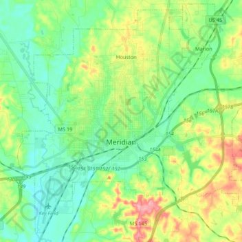
Name: Topografische Karte Meridian, Höhe, Relief.
Ort: Meridian, Lauderdale County, Mississippi, United States (32.31238 -88.77360 32.43978 -88.61034)
Durchschnittliche Höhe: 118 m
Minimale Höhe: 78 m
Maximale Höhe: 205 m
Spenden
Rüste dich für dein nächstes Abenteuer:
Als Amazon-Partner verdient diese Seite an qualifizierten Käufen, ohne dass Ihnen zusätzliche Kosten entstehen.
Andere topografische Karten
Klicken Sie auf eine Karte, um ihre Topografie, ihre Höhe und ihr Relief anzuzeigen.