
Topografische Karte Tasmania
Interaktive Karte
Klicken Sie auf die Karte, um die Höhe anzuzeigen.
Über diese Karte
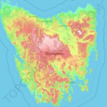
Name: Topografische Karte Tasmania, Höhe, Relief.
Ort: Tasmania, Australia (-43.64304 144.60734 -40.64139 148.35910)
Durchschnittliche Höhe: 220 m
Minimale Höhe: -3 m
Maximale Höhe: 1’524 m
The most mountainous region is the Central Highlands area, which covers most of the central western parts of the state. The Midlands located in the central east, is fairly flat, and is predominantly used for agriculture, although farming activity is scattered throughout the state. Tasmania's tallest mountain is Mount Ossa at 1,617 m (5,305 ft). Much of Tasmania is still densely forested, with the Southwest National Park and neighbouring areas holding some of the last temperate rain forests in the Southern Hemisphere. The Tarkine, containing Savage River National Park located in the island's far north west, is the largest temperate rainforest area in Australia covering about 3,800 square kilometres (1,500 sq mi). With its rugged topography, Tasmania has a great number of rivers. Several of Tasmania's largest rivers have been dammed at some point to provide hydroelectricity. Many rivers begin in the Central Highlands and flow out to the coast. Tasmania's major population centres are mainly situated around estuaries (some of which are named rivers).
Andere topografische Karten
Klicken Sie auf eine Karte, um ihre Topografie, ihre Höhe und ihr Relief anzuzeigen.
Goulds Country
Goulds Country, Break O'Day, Tasmania, 7216, Australia
Durchschnittliche Höhe: 308 m
Vale of Belvoir Conservation Area
Vale of Belvoir Conservation Area, Kentish, Tasmania, Australia
Durchschnittliche Höhe: 866 m
Lake Belton
Lake Belton, Derwent Valley, Tasmania, Australia
Durchschnittliche Höhe: 1’056 m
Erith Island
Erith Island, Flinders Council, Tasmania, Australia
Durchschnittliche Höhe: 23 m
Chicken Island
Chicken Island, Huon Valley, Tasmania, Australia
Durchschnittliche Höhe: 4 m
West Hobart
West Hobart, Hobart, City of Hobart, Tasmania, 7000, Australia
Durchschnittliche Höhe: 105 m
Mount Nelson
Mount Nelson, Hobart, City of Hobart, Tasmania, 7007, Australia
Durchschnittliche Höhe: 198 m
Scottsdale
Scottsdale, Dorset, Tasmania, 7260, Australia
Durchschnittliche Höhe: 179 m
Lake Pedder
Australia > Tasmania > Strathgordon
Lake Pedder, Strathgordon, Derwent Valley, Tasmania, Australia
Durchschnittliche Höhe: 366 m
Mersey Forest
Mersey Forest, Meander Valley, Tasmania, Australia
Durchschnittliche Höhe: 866 m
Launceston
Launceston, City of Launceston, Tasmania, Australia
Durchschnittliche Höhe: 194 m
Waratah-Wynyard
Waratah-Wynyard, Tasmania, Australia
Durchschnittliche Höhe: 347 m
Port Arthur
Port Arthur, Tasman, Tasmania, 7182, Australia
Durchschnittliche Höhe: 153 m
Highland Waters
Australia > Tasmania > London Lakes
Highland Waters, London Lakes, Central Highlands, Tasmania, Australia
Durchschnittliche Höhe: 759 m
Bullock Hill
Bullock Hill, Grove, Huon Valley, Tasmania, Australia
Durchschnittliche Höhe: 147 m
Grey Mares Tail
Australia > Tasmania > St Marys
Grey Mares Tail, St Marys, Break O'Day, Tasmania, Australia
Durchschnittliche Höhe: 349 m
Anderson Island
Anderson Island, Flinders Council, Tasmania, Australia
Durchschnittliche Höhe: 4 m
Flinders Island
Flinders Island, Tasmania, 7255, Australia
Durchschnittliche Höhe: 20 m
Macquarie Island
Macquarie Island, Huon Valley, Tasmania, Australia
Durchschnittliche Höhe: 20 m
Bruny Island
Australia > Tasmania > Alonnah
Bruny Island, Alonnah, Kingborough, Tasmania, Australia
Durchschnittliche Höhe: 59 m
Deal Island
Deal Island, Flinders Council, Tasmania, Australia
Durchschnittliche Höhe: 45 m
Hope Island
Hope Island, Huon Valley, Tasmania, Australia
Durchschnittliche Höhe: 7 m