
Topografische Karte Town of Guilderland
Interaktive Karte
Klicken Sie auf die Karte, um die Höhe anzuzeigen.
Über diese Karte
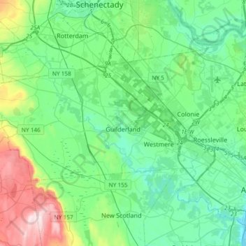
Name: Topografische Karte Town of Guilderland, Höhe, Relief.
Ort: Town of Guilderland, Albany County, New York, United States (42.65915 -74.10672 42.76064 -73.81251)
Durchschnittliche Höhe: 126 m
Minimale Höhe: 2 m
Maximale Höhe: 551 m
Andere topografische Karten
Klicken Sie auf eine Karte, um ihre Topografie, ihre Höhe und ihr Relief anzuzeigen.
City of Albany
United States > New York > Albany County
City of Albany, Albany County, New York, United States
Durchschnittliche Höhe: 68 m
Horton Falls
United States > New York > Albany County > Town of New Scotland
Horton Falls, Town of New Scotland, Albany County, New York, 12159, United States
Durchschnittliche Höhe: 88 m
Town of Berne
United States > New York > Albany County
Town of Berne, Albany County, New York, United States
Durchschnittliche Höhe: 439 m
City of Cohoes
United States > New York > Albany County > City of Cohoes
City of Cohoes, Albany County, New York, 12047, United States
Durchschnittliche Höhe: 39 m
Albany
United States > New York > Albany County > Albany
Albany, Albany County, New York, 12207, United States
Durchschnittliche Höhe: 114 m