
Topografische Karte Kilbirnie
Interaktive Karte
Klicken Sie auf die Karte, um die Höhe anzuzeigen.
Über diese Karte
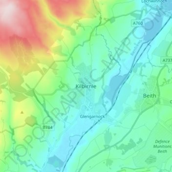
Name: Topografische Karte Kilbirnie, Höhe, Relief.
Ort: Kilbirnie, North Ayrshire, Scotland, KA25 7BY, United Kingdom (55.71519 -4.72551 55.79519 -4.64551)
Durchschnittliche Höhe: 121 m
Minimale Höhe: 23 m
Maximale Höhe: 443 m
Andere topografische Karten
Klicken Sie auf eine Karte, um ihre Topografie, ihre Höhe und ihr Relief anzuzeigen.
Grangehill
United Kingdom > Scotland > North Ayrshire > Beith
Grangehill, Beith, North Ayrshire, Scotland, KA15 2JJ, United Kingdom
Durchschnittliche Höhe: 96 m
Ballochmartin
United Kingdom > Scotland > North Ayrshire > Millport > Ballochmartin
Ballochmartin, Millport, North Ayrshire, Scotland, KA28 0HQ, United Kingdom
Durchschnittliche Höhe: 22 m
Kilwinning
United Kingdom > Scotland > North Ayrshire
Kilwinning, North Ayrshire, Scotland, KA13 6AD, United Kingdom
Durchschnittliche Höhe: 36 m
Ardrossan
United Kingdom > Scotland > North Ayrshire
Ardrossan, North Ayrshire, Scotland, KA22 8BS, United Kingdom
Durchschnittliche Höhe: 21 m
Irvine
United Kingdom > Scotland > North Ayrshire
Irvine, North Ayrshire, Scotland, KA12 0AX, United Kingdom
Durchschnittliche Höhe: 13 m