
Topografische Karte Meltham
Klicken Sie auf die Karte, um die Höhe anzuzeigen.
Über diese Karte
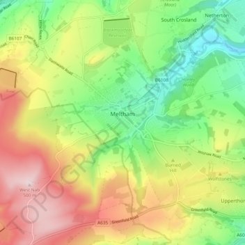
Name: Topografische Karte Meltham, Höhe, Relief.
Ort: Meltham, Kirklees, West Yorkshire, England, United Kingdom (53.56447 -1.90694 53.61519 -1.81310)
Durchschnittliche Höhe: 278 m
Minimale Höhe: 106 m
Maximale Höhe: 497 m
Andere topografische Karten
Klicken Sie auf eine Karte, um ihre Topografie, ihre Höhe und ihr Relief anzuzeigen.
Slaithwaite
United Kingdom > England > Kirklees
In the 1848 edition of 'A Topographical Dictionary of England', Samuel Lewis (the editor) wrote:- "the lands are in meadow and pasture, with a small portion of arable; the scenery is bold and romantic. In the quarries of the district are found vegetable fossils, especially firs and other mountain trees. The…
Durchschnittliche Höhe: 241 m
Hill Top
United Kingdom > England > Kirklees > Hinchcliffe Mill > Hill Top
Durchschnittliche Höhe: 293 m
Clayton West
United Kingdom > England > Kirklees
Listed as Clayton, West, the village featured in "A Topographical Dictionary of England" which was published by Samuel Lewis, London, 1848. In 1848 the village had 1440 residents and was described as being 1080 acres belonging to various owners. Mining was listed as the predominant industry, along with the…
Durchschnittliche Höhe: 150 m
Linfit Hill
United Kingdom > England > Kirklees > Emley Moor > Linfit Fold
Durchschnittliche Höhe: 201 m
Storthes Hall Park Campus
United Kingdom > England > Kirklees > Kirkburton
Durchschnittliche Höhe: 173 m