
Spenden
Rüste dich für dein nächstes Abenteuer:
Als Amazon-Partner verdient diese Seite an qualifizierten Käufen, ohne dass Ihnen zusätzliche Kosten entstehen.
Topografische Karte Anderson Island
Klicken Sie auf die Karte, um die Höhe anzuzeigen.
Spenden
Rüste dich für dein nächstes Abenteuer:
Als Amazon-Partner verdient diese Seite an qualifizierten Käufen, ohne dass Ihnen zusätzliche Kosten entstehen.
Über diese Karte
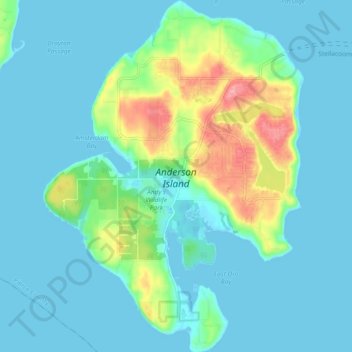
Name: Topografische Karte Anderson Island, Höhe, Relief.
Durchschnittliche Höhe: 20 m
Minimale Höhe: -3 m
Maximale Höhe: 105 m
Spenden
Rüste dich für dein nächstes Abenteuer:
Als Amazon-Partner verdient diese Seite an qualifizierten Käufen, ohne dass Ihnen zusätzliche Kosten entstehen.
Andere topografische Karten
Klicken Sie auf eine Karte, um ihre Topografie, ihre Höhe und ihr Relief anzuzeigen.
Mount Rainier
United States > Washington > Pierce County
Mount Rainier (/reɪˈnɪər/), indigenously known as Tahoma, Tacoma, Tacobet, or təqʷubəʔ, is a large active stratovolcano in the Cascade Range of the Pacific Northwest, located in Mount Rainier National Park about 59 miles (95 km) south-southeast of Seattle. With a summit elevation of 14,411 ft (4,392…
Durchschnittliche Höhe: 3’911 m
Spenden
Rüste dich für dein nächstes Abenteuer:
Als Amazon-Partner verdient diese Seite an qualifizierten Käufen, ohne dass Ihnen zusätzliche Kosten entstehen.
Spenden
Rüste dich für dein nächstes Abenteuer:
Als Amazon-Partner verdient diese Seite an qualifizierten Käufen, ohne dass Ihnen zusätzliche Kosten entstehen.
Puyallup
United States > Washington > Pierce County > Puyallup > Puyallup
Durchschnittliche Höhe: 67 m
Gig Harbor
United States > Washington > Pierce County > Gig Harbor > Gig Harbor
Durchschnittliche Höhe: 49 m
Mount Rainier
United States > Washington > Pierce County
Mount Rainier (/reɪˈnɪər/ ray-NEER), also known as Tahoma, is a large active stratovolcano in the Cascade Range of the Pacific Northwest in the United States. The mountain is located in Mount Rainier National Park about 59 miles (95 km) south-southeast of Seattle. With a summit elevation of 14,411 ft…
Durchschnittliche Höhe: 3’911 m
Mount Rainier
United States > Washington > Pierce County
Mount Rainier (/reɪˈnɪər/ ray-NEER), also known as Tahoma, is a large active stratovolcano in the Cascade Range of the Pacific Northwest in the United States. The mountain is located in Mount Rainier National Park about 59 miles (95 km) south-southeast of Seattle. With an officially recognized summit…
Durchschnittliche Höhe: 3’911 m
Spenden
Rüste dich für dein nächstes Abenteuer:
Als Amazon-Partner verdient diese Seite an qualifizierten Käufen, ohne dass Ihnen zusätzliche Kosten entstehen.
Spenden
Rüste dich für dein nächstes Abenteuer:
Als Amazon-Partner verdient diese Seite an qualifizierten Käufen, ohne dass Ihnen zusätzliche Kosten entstehen.
Spenden
Rüste dich für dein nächstes Abenteuer:
Als Amazon-Partner verdient diese Seite an qualifizierten Käufen, ohne dass Ihnen zusätzliche Kosten entstehen.
Spenden
Rüste dich für dein nächstes Abenteuer:
Als Amazon-Partner verdient diese Seite an qualifizierten Käufen, ohne dass Ihnen zusätzliche Kosten entstehen.
Lakewood
United States > Washington > Pierce County > Lakewood > Lakewood
Durchschnittliche Höhe: 80 m
Spenden
Rüste dich für dein nächstes Abenteuer:
Als Amazon-Partner verdient diese Seite an qualifizierten Käufen, ohne dass Ihnen zusätzliche Kosten entstehen.