
Topografische Karte Fayetteville
Interaktive Karte
Klicken Sie auf die Karte, um die Höhe anzuzeigen.
Über diese Karte
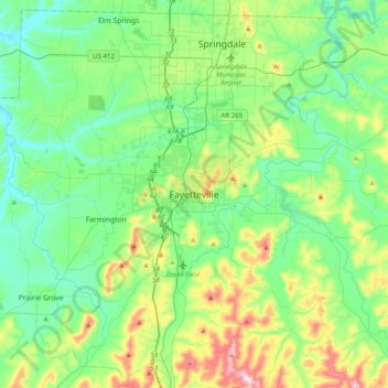
Name: Topografische Karte Fayetteville, Höhe, Relief.
Durchschnittliche Höhe: 404 m
Minimale Höhe: 310 m
Maximale Höhe: 674 m
...yet I venture the assertion that nowhere in said country—or for that matter, in any part of the state—could be found a lovelier elevation, or a lovelier grove of graceful oaks, or a more commanding view, or, in fine, a spot better suited and adapted for the purposes designated than the one chosen for said University site and farm.
Andere topografische Karten
Klicken Sie auf eine Karte, um ihre Topografie, ihre Höhe und ihr Relief anzuzeigen.
South Mountain
United States > Arkansas > Washington County > Fayetteville
South Mountain, Fayetteville, Washington County, Arkansas, 72701, United States
Durchschnittliche Höhe: 405 m
Washington Mountain
United States > Arkansas > Washington County > Fayetteville
Washington Mountain, Fayetteville, Washington County, Arkansas, United States
Durchschnittliche Höhe: 409 m