
Spenden
Rüste dich für dein nächstes Abenteuer:
Als Amazon-Partner verdient diese Seite an qualifizierten Käufen, ohne dass Ihnen zusätzliche Kosten entstehen.
Topografische Karte Crystal Lake
Klicken Sie auf die Karte, um die Höhe anzuzeigen.
Spenden
Rüste dich für dein nächstes Abenteuer:
Als Amazon-Partner verdient diese Seite an qualifizierten Käufen, ohne dass Ihnen zusätzliche Kosten entstehen.
Crystal Lake
The CDP is home to Crystal Lake, a 187-acre (76 ha) lake that straddles the border between Ellington and Stafford. Most of the lake shore is occupied by private residences, but there is a small public beach called Sandy Beach on the south side of the lake. The lake has an average depth of 20 feet (6.1 m), a maximum depth of 50 feet (15 m) and an elevation of 637 feet (194 m).
Spenden
Rüste dich für dein nächstes Abenteuer:
Als Amazon-Partner verdient diese Seite an qualifizierten Käufen, ohne dass Ihnen zusätzliche Kosten entstehen.
Über diese Karte
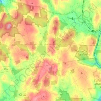
Name: Topografische Karte Crystal Lake, Höhe, Relief.
Durchschnittliche Höhe: 213 m
Minimale Höhe: 113 m
Maximale Höhe: 315 m
Spenden
Rüste dich für dein nächstes Abenteuer:
Als Amazon-Partner verdient diese Seite an qualifizierten Käufen, ohne dass Ihnen zusätzliche Kosten entstehen.