Geolokalisieren

Topografische Karte Moncrivello

Interaktive Karte

Klicken Sie auf die Karte, um die Höhe anzuzeigen.

Über diese Karte

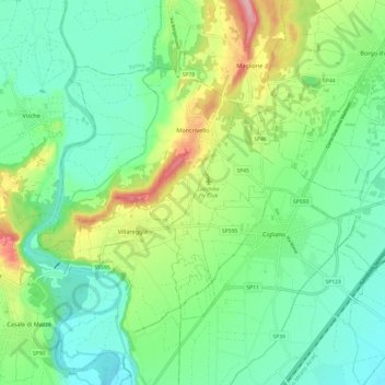
Name: Topografische Karte Moncrivello, Höhe, Relief.

Ort: Moncrivello, Vercelli, Piedmont, Italy (45.29057 7.94684 45.34654 8.06756)

Durchschnittliche Höhe: 242 m

Minimale Höhe: 192 m

Maximale Höhe: 358 m

Andere topografische Karten

Klicken Sie auf eine Karte, um ihre Topografie, ihre Höhe und ihr Relief anzuzeigen.

Santhià

Italy > Piedmont > Vercelli

Santhià, Vercelli, Piedmont, 13048, Italy

Durchschnittliche Höhe: 196 m

Alagna Valsesia

Italy > Piedmont > Vercelli

Alagna Valsesia, Vercelli, Piedmont, 13021, Italy

Durchschnittliche Höhe: 2’071 m

sn3

Italy > Piedmont > Vercelli > Rassa

sn3, Rassa, Vercelli, Piedmont, Italy

Durchschnittliche Höhe: 1’833 m

Mollie

Italy > Piedmont > Vercelli > Cellio con Breia > Mollie

Mollie, Cellio con Breia, Vercelli, Piedmont, 13024, Italy

Durchschnittliche Höhe: 538 m