
Topografische Karte Eminence
Interaktive Karte
Klicken Sie auf die Karte, um die Höhe anzuzeigen.
Über diese Karte
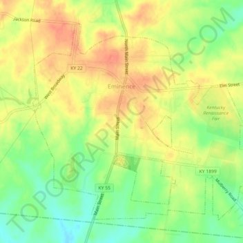
Name: Topografische Karte Eminence, Höhe, Relief.
Ort: Eminence, Henry County, Kentucky, 40019, United States (38.35079 -85.19681 38.37916 -85.15221)
Durchschnittliche Höhe: 274 m
Minimale Höhe: 249 m
Maximale Höhe: 293 m
According to the United States Census Bureau, the city of Eminence has a total area of 2.9 square miles (7.4 km2), of which 0.04 square miles (0.1 km2), or 1.70%, is water. The city is located on high ground, with elevations up to 960 feet (290 m), where several watersheds converge. The source of the Little Kentucky River, a tributary of the Kentucky River, is just west of Eminence, while Town Creek to the north and Drennon Creek to the east also rise in Eminence and flow north to the Kentucky River. Fox Run rises in the southern part of Eminence and flows south via Bullskin Creek and Brashears Creek to the Salt River. The Kentucky and the Salt River are both tributaries of the Ohio River.
Andere topografische Karten
Klicken Sie auf eine Karte, um ihre Topografie, ihre Höhe und ihr Relief anzuzeigen.
Pleasureville
United States > Kentucky > Henry County
Pleasureville, Henry County, Kentucky, United States
Durchschnittliche Höhe: 269 m