
Topografische Karte Bâlea Lake
Interaktive Karte
Klicken Sie auf die Karte, um die Höhe anzuzeigen.
Über diese Karte
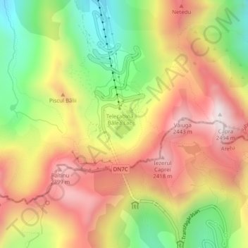
Name: Topografische Karte Bâlea Lake, Höhe, Relief.
Ort: Bâlea Lake, Cârțișoara, Sibiu, Romania (45.60176 24.61549 45.60483 24.61897)
Durchschnittliche Höhe: 2’080 m
Minimale Höhe: 1’662 m
Maximale Höhe: 2’457 m
Bâlea Lake (Romanian: Lacul Bâlea or Bâlea Lac, pronounced [ˈbɨle̯a]; Hungarian: Bilea-tó) is a glacier lake situated at 2,034 m of altitude in the Făgăraș Mountains, in central Romania, in Cârțișoara, Sibiu County. There are two chalets opened all the year round, a meteorological station and a mountain rescue (Salvamont) station. It is accessible by car on the Transfăgărășan road during the summer, and the rest of the year by a cable car from the "Bâlea Cascadă" chalet.
Andere topografische Karten
Klicken Sie auf eine Karte, um ihre Topografie, ihre Höhe und ihr Relief anzuzeigen.
Cârțișoara
Romania > Sibiu > Cârțișoara
Cârțișoara, Sibiu, 557075, Romania
Durchschnittliche Höhe: 501 m