
Topografische Karte Bas-Rhin
Klicken Sie auf die Karte, um die Höhe anzuzeigen.
Bas-Rhin
Le château du Haut-Koenigsbourg : construit au XII siècle, il domine la plaine d’Alsace à plus de 700 mètres d’altitude. Détruit lors de la guerre de Trente Ans, il est restauré de 1900 à 1908 par l’empereur allemand Guillaume II. Il accueille une importante collection d’armes et de meubles de l’époque.
Über diese Karte
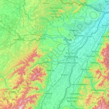
Name: Topografische Karte Bas-Rhin, Höhe, Relief.
Durchschnittliche Höhe: 315 m
Minimale Höhe: 104 m
Maximale Höhe: 1’274 m
Andere topografische Karten
Klicken Sie auf eine Karte, um ihre Topografie, ihre Höhe und ihr Relief anzuzeigen.
Le Markstein
France > Grand Est > Haut-Rhin > Fellering
Le Markstein est une station de sports d'hiver, d'été et de détente (luge d'été et parapente) française, située dans le massif des Vosges, comprise entre 1 040 et 1 265 m d'altitude sur le passage de la route des Crêtes. Elle forme un ensemble de ski de fond avec le site du Breitfirst et la haute route…
Durchschnittliche Höhe: 1’013 m
Vosges
France > Grand Est > Goldbach-Altenbach
Les Vosges sont un massif de moyennes montagnes du Nord-Est de la France qui sépare le plateau lorrain de la plaine d'Alsace. D'origine varisque et majoritairement constituées de grès et de granite, elles atteignent des altitudes modestes culminant à 1 424 mètres au Grand Ballon.
Durchschnittliche Höhe: 864 m
Col de la Schlucht
France > Grand Est > Vosges > Le Valtin > La Schlucht
Situé à une altitude de 1 139 mètres, le col de la Schlucht fait communiquer les vallées lorraines de la Meurthe et de la Vologne avec la vallée alsacienne de la Fecht, un affluent de l'Ill. Les sources de la Meurthe et de la Fecht sont voisines du col de la Schlucht. La première coule sur les hauteurs…
Durchschnittliche Höhe: 1’068 m
Petit Ballon
France > Grand Est > Haut-Rhin > Linthal
Le Petit Ballon (Kahler Wasen ou Kleiner Belchen en allemand) est un sommet secondaire du massif des Vosges situé dans le département du Haut-Rhin (Grand Est). Il culmine à 1 272 mètres d'altitude. Son sommet donne un point de vue panoramique, marqué par une statue de la Vierge et une antenne-relais…
Durchschnittliche Höhe: 1’050 m
Trouée de Belfort
France > Grand Est > Haut-Rhin > Valdieu-Lutran
Le point le plus haut est le mont Salbert, à 651 m d'altitude. Le point le plus bas est la vallée du Doubs à Montbéliard, à 315 m d'altitude.
Durchschnittliche Höhe: 352 m
Château du Haut-Kœnigsbourg
France > Grand Est > Bas-Rhin > Orschwiller > Schaflager
Le château est situé dans le massif des Vosges à une altitude de 757 m à 12 km à l'ouest de Sélestat d'où il est visible. Il se trouve également à 26 km au nord de Colmar d'où il est également visible par temps clair et à 55 km au sud de Strasbourg.
Durchschnittliche Höhe: 442 m
Groupe fortifié Verdun
France > Grand Est > Moselle > Augny
Le périmètre de protection du groupe Verdun est assuré par un ensemble de positions d’infanterie, de casernes fortifiées et de batteries d’artillerie, disséminés sur une vaste superficie et dissimulés par la topographie naturelle. À partir de 1899, le plan Schlieffen de l’état-major allemand…
Durchschnittliche Höhe: 244 m
Grand Canal d'Alsace
France > Grand Est > Haut-Rhin > Vogelgrun
Le Rhin antérieur est issu de plusieurs sources dans l'Ouest du Surselva et se dirige ensuite vers l'est. L'une de ces sources, située au lac de Toma à 2 345 m d'altitude, est généralement considérée comme la source du Rhin ; le lac s'écoule ensuite dans le Rein da Tuma (de). Le lac de Toma n'est pas…
Durchschnittliche Höhe: 192 m
Réserve biologique dirigée des Vallons de Gorze
France > Grand Est > Moselle > Gorze > Saint-Thiébaut
Durchschnittliche Höhe: 272 m
La Bouillant
France > Grand Est > Aube > Aix-Villemaur-Pâlis > Aix-en-Othe
Durchschnittliche Höhe: 206 m
Les Rosaux
France > Grand Est > Meurthe-et-Moselle > Neuviller-sur-Moselle
Durchschnittliche Höhe: 266 m
Réserve biologique dirigée de Faux de Verzy
France > Grand Est > Marne > Verzy
Durchschnittliche Höhe: 248 m
Étang de la Besace
France > Grand Est > Vosges > Dommartin-lès-Remiremont
Durchschnittliche Höhe: 669 m
Sur la Route de Malleroy
France > Grand Est > Meurthe-et-Moselle > Custines
Durchschnittliche Höhe: 252 m
Les Grandes Côtes
France > Grand Est > Marne > Sainte-Marie-du-Lac-Nuisement
Durchschnittliche Höhe: 132 m
Lac du Forlet
France > Grand Est > Haut-Rhin > Soultzeren
Le lac des Truites, ou lac du Forlet, est le plus élevé des lacs vosgiens à 1 066 m d'altitude. Il est dénommé Forlenweier en alsacien et reïf tou blan en welsch.
Durchschnittliche Höhe: 1’134 m
Col du Grand Ballon
France > Grand Est > Haut-Rhin > Soultz-Haut-Rhin
La route des Crêtes contourne le sommet par l'est, franchissant un col à l'altitude de 1 341 mètres, entre le Markstein et le Hartmannswillerkopf (Vieil Armand).
Durchschnittliche Höhe: 1’143 m
Plateau de Malzéville
France > Grand Est > Dommartemont
D'une surface de 557 hectares (plateau et butte Sainte Geneviève), le plateau, majoritairement boisé de résineux, est classé site d'importance communautaire. Sa surface classée Natura 2000 représente 439 ha. Il culmine à 384 mètres d'altitude.
Durchschnittliche Höhe: 314 m
Ballon d'Alsace
France > Grand Est > Haut-Rhin > Sewen
Le ballon d'Alsace, qui culmine à 1 247 mètres d'altitude, est l'un des premiers sommets significatifs lorsqu'on aborde le massif des Vosges par le sud. Il offre ainsi un large panorama, la Forêt-Noire à l'est, le Jura, la trouée de Belfort et, par temps clair, la chaîne des Alpes bernoises et le mont…
Durchschnittliche Höhe: 994 m