
Topografische Karte Rural Municipality of Yellowhead
Interaktive Karte
Klicken Sie auf die Karte, um die Höhe anzuzeigen.
Über diese Karte
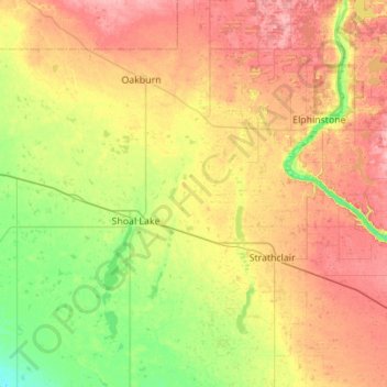
Name: Topografische Karte Rural Municipality of Yellowhead, Höhe, Relief.
Durchschnittliche Höhe: 575 m
Minimale Höhe: 531 m
Maximale Höhe: 627 m
Andere topografische Karten
Klicken Sie auf eine Karte, um ihre Topografie, ihre Höhe und ihr Relief anzuzeigen.
Elphinstone
Canada > Manitoba > Division No. 15 > Rural Municipality of Yellowhead
Elphinstone, Rural Municipality of Yellowhead, Division No. 15, Manitoba, Canada
Durchschnittliche Höhe: 583 m
Rowland Lake
Canada > Manitoba > Division No. 15 > Rural Municipality of Rosedale
Rowland Lake, Rural Municipality of Rosedale, Division No. 15, Manitoba, Canada
Durchschnittliche Höhe: 692 m
Municipality of Harrison Park
Canada > Manitoba > Division No. 15
Municipality of Harrison Park, Division No. 15, Manitoba, Canada
Durchschnittliche Höhe: 615 m
Miniota
Canada > Manitoba > Division No. 15 > Prairie View Municipality
Miniota, Prairie View Municipality, Division No. 15, Manitoba, R0M 1M0, Canada
Durchschnittliche Höhe: 434 m
Rural Municipality of Minto - Odanah
Canada > Manitoba > Division No. 15
Rural Municipality of Minto - Odanah, Division No. 15, Manitoba, Canada, Jacksons Lake
Durchschnittliche Höhe: 587 m
Kerrs Lake
Canada > Manitoba > Division No. 15 > Municipality of Clanwilliam – Erickson
Kerrs Lake, Municipality of Clanwilliam – Erickson, Division No. 15, Manitoba, Canada
Durchschnittliche Höhe: 670 m
Beaufort Lake
Canada > Manitoba > Division No. 15 > Municipality of Harrison Park > Sandy Lake
Beaufort Lake, Sandy Lake, Municipality of Harrison Park, Division No. 15, Manitoba, Canada
Durchschnittliche Höhe: 613 m
Municipality of Clanwilliam – Erickson
Canada > Manitoba > Division No. 15
Municipality of Clanwilliam – Erickson, Division No. 15, Manitoba, R0J 0P0, Canada
Durchschnittliche Höhe: 630 m
Onanole
Canada > Manitoba > Division No. 15 > Municipality of Harrison Park
Onanole, Municipality of Harrison Park, Division No. 15, Manitoba, R0J 1N0, Canada
Durchschnittliche Höhe: 627 m
Rolling River
Canada > Manitoba > Division No. 15
Rolling River, Division No. 15, Manitoba, Canada
Durchschnittliche Höhe: 610 m
Shoal Lake
Canada > Manitoba > Division No. 15
Shoal Lake, Division No. 15, Manitoba, R0J 1Z0, Canada
Durchschnittliche Höhe: 557 m
Rural Municipality of Rosedale
Canada > Manitoba > Division No. 15 > Rural Municipality of Rosedale
Rural Municipality of Rosedale, Division No. 15, Manitoba, R0J 0Y0, Canada
Durchschnittliche Höhe: 484 m
Neepawa
Canada > Manitoba > Division No. 15
Neepawa, Division No. 15, Manitoba, R0J 1H0, Canada
Durchschnittliche Höhe: 369 m