
Topografische Karte Longlac
Klicken Sie auf die Karte, um die Höhe anzuzeigen.
Über diese Karte
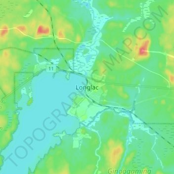
Name: Topografische Karte Longlac, Höhe, Relief.
Durchschnittliche Höhe: 323 m
Minimale Höhe: 309 m
Maximale Höhe: 364 m
Andere topografische Karten
Klicken Sie auf eine Karte, um ihre Topografie, ihre Höhe und ihr Relief anzuzeigen.
Wapikaimaski Lake
Canada > Ontario > Thunder Bay District > Unorganized Thunder Bay District
Durchschnittliche Höhe: 437 m
Whitefish Lake
Canada > Ontario > Thunder Bay District > Unorganized Thunder Bay District
Durchschnittliche Höhe: 472 m
Lac des Mille Lacs
Canada > Ontario > Thunder Bay District > Unorganized Thunder Bay District
Durchschnittliche Höhe: 469 m
Sunbow Lake
Canada > Ontario > Thunder Bay District > Unorganized Thunder Bay District
Durchschnittliche Höhe: 491 m
Unorganized Thunder Bay District
Canada > Ontario > Thunder Bay District
Durchschnittliche Höhe: 344 m
Ouimet Canyon Provincial Park
Canada > Ontario > Thunder Bay District > Dorion Township
Durchschnittliche Höhe: 364 m
Sulphur Lake
Canada > Ontario > Thunder Bay District > Unorganized Thunder Bay District
Durchschnittliche Höhe: 467 m
Trowbridge Island
Canada > Ontario > Thunder Bay District > Unorganized Thunder Bay District
Durchschnittliche Höhe: 179 m
Lower Ross Lake
Canada > Ontario > Thunder Bay District > Unorganized Thunder Bay District
Durchschnittliche Höhe: 393 m
Joyce Lake
Canada > Ontario > Thunder Bay District > Unorganized Thunder Bay District
Durchschnittliche Höhe: 391 m
Quint Island Lake;Shacabac Creek
Canada > Ontario > Thunder Bay District > Unorganized Thunder Bay District
Durchschnittliche Höhe: 283 m
Whitefish Lake
Canada > Ontario > Thunder Bay District > Unorganized Thunder Bay District > Suomi
Durchschnittliche Höhe: 456 m
Tomlinson Lake
Canada > Ontario > Thunder Bay District > Unorganized Thunder Bay District
Durchschnittliche Höhe: 489 m
Burness Lake
Canada > Ontario > Thunder Bay District > Unorganized Thunder Bay District
Durchschnittliche Höhe: 301 m
North Lake
Canada > Ontario > Thunder Bay District > Unorganized Thunder Bay District
Durchschnittliche Höhe: 523 m
Arrow Lake
Canada > Ontario > Thunder Bay District > Unorganized Thunder Bay District
Durchschnittliche Höhe: 521 m
Pass Lake
Canada > Ontario > Thunder Bay District > Unorganized Thunder Bay District
Durchschnittliche Höhe: 259 m
Miniss Lake
Canada > Ontario > Thunder Bay District > Unorganized Thunder Bay District
Durchschnittliche Höhe: 394 m
Sleeping Giant Provincial Park
Canada > Ontario > Thunder Bay District > Unorganized Thunder Bay District
Durchschnittliche Höhe: 204 m
Perute Lake
Canada > Ontario > Thunder Bay District > Unorganized Thunder Bay District
Durchschnittliche Höhe: 410 m
Harvey Lake
Canada > Ontario > Thunder Bay District > Unorganized Thunder Bay District
Durchschnittliche Höhe: 297 m
Horne Creek;Horne Lake
Canada > Ontario > Thunder Bay District > Unorganized Thunder Bay District
Durchschnittliche Höhe: 443 m
Ruffle Lake
Canada > Ontario > Thunder Bay District > Unorganized Thunder Bay District
Durchschnittliche Höhe: 326 m
Ara Lake
Canada > Ontario > Thunder Bay District > Unorganized Thunder Bay District
Durchschnittliche Höhe: 308 m
Papineau Lake;Wapoose Creek
Canada > Ontario > Thunder Bay District > Greenstone
Durchschnittliche Höhe: 347 m
Paint Lake
Canada > Ontario > Thunder Bay District > Unorganized Thunder Bay District
Durchschnittliche Höhe: 450 m
O'Brien Lake
Canada > Ontario > Thunder Bay District > Unorganized Thunder Bay District
Durchschnittliche Höhe: 205 m
Kapikotongwa River
Canada > Ontario > Thunder Bay District > Unorganized Thunder Bay District
Durchschnittliche Höhe: 268 m
Timmus Lake
Canada > Ontario > Thunder Bay District > Unorganized Thunder Bay District
Durchschnittliche Höhe: 461 m
DeCourcey Lake
Canada > Ontario > Thunder Bay District > Unorganized Thunder Bay District
Durchschnittliche Höhe: 457 m
Cash Creek
Canada > Ontario > Thunder Bay District > Unorganized Thunder Bay District
Durchschnittliche Höhe: 221 m
Whitesand Lake
Canada > Ontario > Thunder Bay District > Unorganized Thunder Bay District
Durchschnittliche Höhe: 318 m
Squash Lake
Canada > Ontario > Thunder Bay District > Unorganized Thunder Bay District
Durchschnittliche Höhe: 348 m
Wapikaimaski Lake
Canada > Ontario > Thunder Bay District > Unorganized Thunder Bay District
Durchschnittliche Höhe: 437 m
Cola Creek
Canada > Ontario > Thunder Bay District > Unorganized Thunder Bay District
Durchschnittliche Höhe: 479 m
Georgia Lake
Canada > Ontario > Thunder Bay District > Unorganized Thunder Bay District
Durchschnittliche Höhe: 459 m
Unorganized Thunder Bay District
Canada > Ontario > Thunder Bay District
Durchschnittliche Höhe: 344 m
Unorganized Thunder Bay District
Canada > Ontario > Thunder Bay District
Durchschnittliche Höhe: 344 m
Sleeping Giant Provincial Park
Canada > Ontario > Thunder Bay District > Unorganized Thunder Bay District
Durchschnittliche Höhe: 204 m
Topaz Lake
Canada > Ontario > Thunder Bay District > Unorganized Thunder Bay District
Durchschnittliche Höhe: 482 m
District Lake
Canada > Ontario > Thunder Bay District > Unorganized Thunder Bay District
Durchschnittliche Höhe: 481 m