
Spenden
Rüste dich für dein nächstes Abenteuer:
Als Amazon-Partner verdient diese Seite an qualifizierten Käufen, ohne dass Ihnen zusätzliche Kosten entstehen.
Topografische Karte Waterlooville
Klicken Sie auf die Karte, um die Höhe anzuzeigen.
Spenden
Rüste dich für dein nächstes Abenteuer:
Als Amazon-Partner verdient diese Seite an qualifizierten Käufen, ohne dass Ihnen zusätzliche Kosten entstehen.
Über diese Karte
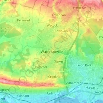
Name: Topografische Karte Waterlooville, Höhe, Relief.
Durchschnittliche Höhe: 43 m
Minimale Höhe: -3 m
Maximale Höhe: 114 m
Spenden
Rüste dich für dein nächstes Abenteuer:
Als Amazon-Partner verdient diese Seite an qualifizierten Käufen, ohne dass Ihnen zusätzliche Kosten entstehen.
Andere topografische Karten
Klicken Sie auf eine Karte, um ihre Topografie, ihre Höhe und ihr Relief anzuzeigen.
Spenden
Rüste dich für dein nächstes Abenteuer:
Als Amazon-Partner verdient diese Seite an qualifizierten Käufen, ohne dass Ihnen zusätzliche Kosten entstehen.
Spenden
Rüste dich für dein nächstes Abenteuer:
Als Amazon-Partner verdient diese Seite an qualifizierten Käufen, ohne dass Ihnen zusätzliche Kosten entstehen.
Basingstoke
United Kingdom > England > Hampshire > Basingstoke and Deane
Situated in a valley through the Hampshire Downs at an average elevation of 88 metres (289 ft) Basingstoke is a major interchange between Reading, Newbury, Andover, Winchester, and Alton, and lies on the natural trade route between the southwest of England and London. The area had been something of an…
Durchschnittliche Höhe: 109 m
Bordon
United Kingdom > England > Hampshire > East Hampshire > Hollywater
Durchschnittliche Höhe: 82 m
Spenden
Rüste dich für dein nächstes Abenteuer:
Als Amazon-Partner verdient diese Seite an qualifizierten Käufen, ohne dass Ihnen zusätzliche Kosten entstehen.
Kingsclere
United Kingdom > England > Hampshire > Basingstoke and Deane > Kingsclere
Durchschnittliche Höhe: 139 m
Spenden
Rüste dich für dein nächstes Abenteuer:
Als Amazon-Partner verdient diese Seite an qualifizierten Käufen, ohne dass Ihnen zusätzliche Kosten entstehen.
Rowlands Castle
United Kingdom > England > Hampshire > East Hampshire > Finchdean
Durchschnittliche Höhe: 72 m
West End Copse
United Kingdom > England > Hampshire > Eastleigh > West End
Durchschnittliche Höhe: 39 m
Spenden
Rüste dich für dein nächstes Abenteuer:
Als Amazon-Partner verdient diese Seite an qualifizierten Käufen, ohne dass Ihnen zusätzliche Kosten entstehen.
Spenden
Rüste dich für dein nächstes Abenteuer:
Als Amazon-Partner verdient diese Seite an qualifizierten Käufen, ohne dass Ihnen zusätzliche Kosten entstehen.
Hayling Island
United Kingdom > England > Hampshire > Havant > North Hayling
An Iron Age shrine in the north of Hayling Island was later developed into a Roman temple in the 1st century BC and was first recorded in Richard Scott's Topographical and Historical Account of Hayling Island (1826). The site was dug between 1897 and 1907 and again from 1976 to 1978. The remains are now buried…
Durchschnittliche Höhe: 1 m
Petersfield
United Kingdom > England > Hampshire > East Hampshire > Sheet
Durchschnittliche Höhe: 73 m
Spenden
Rüste dich für dein nächstes Abenteuer:
Als Amazon-Partner verdient diese Seite an qualifizierten Käufen, ohne dass Ihnen zusätzliche Kosten entstehen.
Tadley
United Kingdom > England > Hampshire > Basingstoke and Deane > Tadley
Durchschnittliche Höhe: 92 m
Spenden
Rüste dich für dein nächstes Abenteuer:
Als Amazon-Partner verdient diese Seite an qualifizierten Käufen, ohne dass Ihnen zusätzliche Kosten entstehen.
Spenden
Rüste dich für dein nächstes Abenteuer:
Als Amazon-Partner verdient diese Seite an qualifizierten Käufen, ohne dass Ihnen zusätzliche Kosten entstehen.
Spenden
Rüste dich für dein nächstes Abenteuer:
Als Amazon-Partner verdient diese Seite an qualifizierten Käufen, ohne dass Ihnen zusätzliche Kosten entstehen.
Hartley Wintney
United Kingdom > England > Hampshire > Hart > Hartley Wintney
Durchschnittliche Höhe: 74 m
Four Marks
United Kingdom > England > Hampshire > East Hampshire > Four Marks
Durchschnittliche Höhe: 185 m
Spenden
Rüste dich für dein nächstes Abenteuer:
Als Amazon-Partner verdient diese Seite an qualifizierten Käufen, ohne dass Ihnen zusätzliche Kosten entstehen.
Horndean
United Kingdom > England > Hampshire > East Hampshire > Horndean
Durchschnittliche Höhe: 92 m
Spenden
Rüste dich für dein nächstes Abenteuer:
Als Amazon-Partner verdient diese Seite an qualifizierten Käufen, ohne dass Ihnen zusätzliche Kosten entstehen.
Rowland's Copse, Red Hill
United Kingdom > England > Hampshire > East Hampshire > Rowlands Castle
Durchschnittliche Höhe: 42 m
Spenden
Rüste dich für dein nächstes Abenteuer:
Als Amazon-Partner verdient diese Seite an qualifizierten Käufen, ohne dass Ihnen zusätzliche Kosten entstehen.
Milford-on-Sea
United Kingdom > England > Hampshire > New Forest > Milford on Sea
Durchschnittliche Höhe: 7 m
Morgaston Wood
United Kingdom > England > Hampshire > Basingstoke and Deane > Sherborne St John
Durchschnittliche Höhe: 76 m
Spenden
Rüste dich für dein nächstes Abenteuer:
Als Amazon-Partner verdient diese Seite an qualifizierten Käufen, ohne dass Ihnen zusätzliche Kosten entstehen.
Newton Valence
United Kingdom > England > Hampshire > East Hampshire
The village sits high in the westernmost chalk hills of the South Downs: maximum elevation 191 metres (627 feet) above sea level. Much of the surrounding landscape is within the East Hampshire Area of Outstanding Natural Beauty.
Durchschnittliche Höhe: 153 m
Spenden
Rüste dich für dein nächstes Abenteuer:
Als Amazon-Partner verdient diese Seite an qualifizierten Käufen, ohne dass Ihnen zusätzliche Kosten entstehen.
Highclere Castle
United Kingdom > England > Hampshire > Basingstoke and Deane
Durchschnittliche Höhe: 166 m
News Wood
United Kingdom > England > Hampshire > Test Valley > King's Somborne
Durchschnittliche Höhe: 93 m
Spenden
Rüste dich für dein nächstes Abenteuer:
Als Amazon-Partner verdient diese Seite an qualifizierten Käufen, ohne dass Ihnen zusätzliche Kosten entstehen.
Spenden
Rüste dich für dein nächstes Abenteuer:
Als Amazon-Partner verdient diese Seite an qualifizierten Käufen, ohne dass Ihnen zusätzliche Kosten entstehen.
Brickkiln Copse
United Kingdom > England > Hampshire > Hart > Hound Green
Durchschnittliche Höhe: 61 m
Spenden
Rüste dich für dein nächstes Abenteuer:
Als Amazon-Partner verdient diese Seite an qualifizierten Käufen, ohne dass Ihnen zusätzliche Kosten entstehen.
Bath Meadows
United Kingdom > England > Hampshire > Test Valley > Wellow > East Wellow
Durchschnittliche Höhe: 30 m
Spenden
Rüste dich für dein nächstes Abenteuer:
Als Amazon-Partner verdient diese Seite an qualifizierten Käufen, ohne dass Ihnen zusätzliche Kosten entstehen.
Bishopstoke
United Kingdom > England > Hampshire > Eastleigh > Bishopstoke
Durchschnittliche Höhe: 25 m
Spenden
Rüste dich für dein nächstes Abenteuer:
Als Amazon-Partner verdient diese Seite an qualifizierten Käufen, ohne dass Ihnen zusätzliche Kosten entstehen.
Spenden
Rüste dich für dein nächstes Abenteuer:
Als Amazon-Partner verdient diese Seite an qualifizierten Käufen, ohne dass Ihnen zusätzliche Kosten entstehen.
Mortimer West End
United Kingdom > England > Hampshire > Basingstoke and Deane > Mortimer West End
Durchschnittliche Höhe: 90 m
Ashmansworth
United Kingdom > England > Hampshire > Basingstoke and Deane
Durchschnittliche Höhe: 187 m
Spenden
Rüste dich für dein nächstes Abenteuer:
Als Amazon-Partner verdient diese Seite an qualifizierten Käufen, ohne dass Ihnen zusätzliche Kosten entstehen.
Spenden
Rüste dich für dein nächstes Abenteuer:
Als Amazon-Partner verdient diese Seite an qualifizierten Käufen, ohne dass Ihnen zusätzliche Kosten entstehen.
Wootton St. Lawrence
United Kingdom > England > Hampshire > Basingstoke and Deane
Durchschnittliche Höhe: 115 m
Spenden
Rüste dich für dein nächstes Abenteuer:
Als Amazon-Partner verdient diese Seite an qualifizierten Käufen, ohne dass Ihnen zusätzliche Kosten entstehen.
Spenden
Rüste dich für dein nächstes Abenteuer:
Als Amazon-Partner verdient diese Seite an qualifizierten Käufen, ohne dass Ihnen zusätzliche Kosten entstehen.