
Spenden
Rüste dich für dein nächstes Abenteuer:
Als Amazon-Partner verdient diese Seite an qualifizierten Käufen, ohne dass Ihnen zusätzliche Kosten entstehen.
Topografische Karte Shookville
Klicken Sie auf die Karte, um die Höhe anzuzeigen.
Spenden
Rüste dich für dein nächstes Abenteuer:
Als Amazon-Partner verdient diese Seite an qualifizierten Käufen, ohne dass Ihnen zusätzliche Kosten entstehen.
Über diese Karte
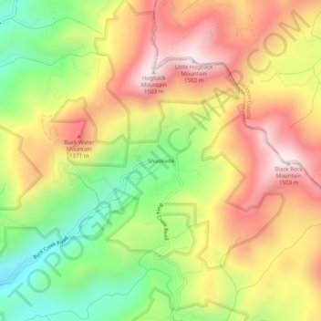
Name: Topografische Karte Shookville, Höhe, Relief.
Ort: Shookville, Macon County, North Carolina, United States (35.12621 -83.24265 35.16621 -83.20265)
Durchschnittliche Höhe: 1’172 m
Minimale Höhe: 841 m
Maximale Höhe: 1’485 m
Spenden
Rüste dich für dein nächstes Abenteuer:
Als Amazon-Partner verdient diese Seite an qualifizierten Käufen, ohne dass Ihnen zusätzliche Kosten entstehen.
Andere topografische Karten
Klicken Sie auf eine Karte, um ihre Topografie, ihre Höhe und ihr Relief anzuzeigen.
Franklin
United States > North Carolina > Macon County
Franklin is characterized by its mountainous terrain, lying within the picturesque Appalachian Mountains. The area features rugged landscapes with elevations typically ranging from around 2,000 to 4,000 feet, creating dramatic vistas and deep valleys. The Little Tennessee River winds through the region, adding…
Durchschnittliche Höhe: 675 m
Highlands
United States > North Carolina > Macon County
Highlands was founded in 1875 after its two founders, Samuel Truman Kelsey and Clinton Carter Hutchinson, drew lines from Chicago to Savannah and from New Orleans to New York City. They felt that the place where these lines met would eventually become a great trading center and commercial crossroads. Highlands…
Durchschnittliche Höhe: 1’116 m
Nantahala National Forest
United States > North Carolina > Macon County
The terrain varies in elevation from 5,800 feet (1,767.8 m) at Lone Bald in Jackson County, to 1,200 feet (365.8 m) in Cherokee County along the Hiwassee River below the Appalachia Dam. It is the home of many western NC waterfalls. The last part of the Mountain Waters Scenic Byway travels through this forest.…
Durchschnittliche Höhe: 781 m
Spenden
Rüste dich für dein nächstes Abenteuer:
Als Amazon-Partner verdient diese Seite an qualifizierten Käufen, ohne dass Ihnen zusätzliche Kosten entstehen.
Highlands
United States > North Carolina > Macon County
Highlands was founded in 1875 after its two founders, Samuel Truman Kelsey and Clinton Carter Hutchinson, drew lines from Chicago to Savannah and from New Orleans to New York City. They felt that the place where these lines met would eventually become a great trading center and commercial crossroads. Highlands…
Durchschnittliche Höhe: 1’116 m
Franklin
United States > North Carolina > Macon County
The height of the falls is given as 200 ft (61 m) in Kevin Adams' book, North Carolina Waterfalls and 250 ft (77.1 m) by NCWaterfalls.com. However, Google Earth gives a height (based on the elevation of the water at the top of the falls and the elevation of the plunge pool at the bottom of the falls) of 137 ft…
Durchschnittliche Höhe: 675 m