Geolokalisieren

Topografische Karte Conroe

Klicken Sie auf die Karte, um die Höhe anzuzeigen.

Conroe

Conroe features a predominantly flat terrain with an average elevation of approximately 220 feet (67 meters) above sea level. The area is characterized by gently rolling hills interspersed with numerous lakes and wetlands, including the prominent Lake Conroe, which spans about 21,000 acres. The lake, formed by the Conroe Dam, contributes to the local ecosystem and recreational opportunities, providing a habitat for diverse wildlife. Surrounding the city, you'll find lush forests, notably the Sam Houston National Forest to the east, which adds to the scenic beauty and biodiversity of the region. This combination of water bodies and wooded areas creates a picturesque landscape, making Conroe an attractive place for both residents and visitors.

Über diese Karte

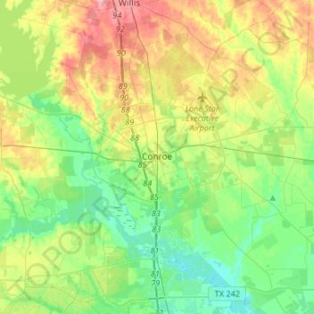
Name: Topografische Karte Conroe, Höhe, Relief.

Ort: Conroe, Montgomery County, Texas, United States (30.20266 -95.65670 30.41999 -95.39094)

Durchschnittliche Höhe: 62 m

Minimale Höhe: 27 m

Maximale Höhe: 123 m

Andere topografische Karten

Klicken Sie auf eine Karte, um ihre Topografie, ihre Höhe und ihr Relief anzuzeigen.

New Caney

United States > Texas > Montgomery County

Durchschnittliche Höhe: 30 m

Stillwater Community

United States > Texas > Montgomery County > Conroe

Durchschnittliche Höhe: 44 m

Mount Zion

United States > Texas > Montgomery County

Durchschnittliche Höhe: 88 m

Bobville

United States > Texas > Montgomery County

Durchschnittliche Höhe: 75 m

Woodland Hills

United States > Texas > Montgomery County > Conroe

Durchschnittliche Höhe: 99 m

Indian Springs

United States > Texas > Montgomery County > The Woodlands

Durchschnittliche Höhe: 48 m

Stillwater Community

United States > Texas > Montgomery County > Conroe

Durchschnittliche Höhe: 44 m

Sterling Ridge

United States > Texas > Montgomery County > The Woodlands

Durchschnittliche Höhe: 58 m

LITTLE LAKE CONROE

United States > Texas > Montgomery County > Conroe

Durchschnittliche Höhe: 77 m

Security

United States > Texas > Montgomery County

Durchschnittliche Höhe: 53 m

Conroe

United States > Texas > Montgomery County > Conroe > Conroe

Durchschnittliche Höhe: 60 m

Benders Landing

United States > Texas > Montgomery County

Durchschnittliche Höhe: 29 m

Porter

United States > Texas > Montgomery County

Durchschnittliche Höhe: 30 m

Lake Egypt

United States > Texas > Montgomery County > Egypt

Durchschnittliche Höhe: 61 m

New Caney

United States > Texas > Montgomery County

Durchschnittliche Höhe: 30 m

Rüste dich für dein nächstes Abenteuer:

🗺️Wanderkarten Schweiz - Topografische und detaillierte Wanderkarten für alle Regionen der Schweiz
🧺Dry Bags / Packsäcke - Hält Kleidung und Elektronik im Rucksack trocken
🧗‍♀️Kletter‑ & Sicherungshandschuhe - Schutz und Grip für Klettertouren
🧢Wandermützen mit UV-Schutz - Sonnenschutz für Kopf und Nacken im Hochgebirge
🔭Kompakt-Ferngläser - Naturbeobachtung mit kristallklarer Optik

Als Amazon-Partner verdient diese Seite an qualifizierten Käufen, ohne dass Ihnen zusätzliche Kosten entstehen.