
Spenden
Rüste dich für dein nächstes Abenteuer:
Als Amazon-Partner verdient diese Seite an qualifizierten Käufen, ohne dass Ihnen zusätzliche Kosten entstehen.
Topografische Karte Tanner Williams
Klicken Sie auf die Karte, um die Höhe anzuzeigen.
Spenden
Rüste dich für dein nächstes Abenteuer:
Als Amazon-Partner verdient diese Seite an qualifizierten Käufen, ohne dass Ihnen zusätzliche Kosten entstehen.
Über diese Karte
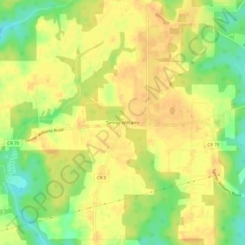
Name: Topografische Karte Tanner Williams, Höhe, Relief.
Durchschnittliche Höhe: 52 m
Minimale Höhe: 31 m
Maximale Höhe: 63 m
Spenden
Rüste dich für dein nächstes Abenteuer:
Als Amazon-Partner verdient diese Seite an qualifizierten Käufen, ohne dass Ihnen zusätzliche Kosten entstehen.
Andere topografische Karten
Klicken Sie auf eine Karte, um ihre Topografie, ihre Höhe und ihr Relief anzuzeigen.
Mobile
United States > Alabama > Mobile County
According to the United States Census Bureau, the city has a total area of 180.1 square miles (466 km2), with 139.5 square miles (361 km2) of it being land, and 40.6 square miles (105.2 km2), or 22.5% of the total, being covered by water. The elevation in Mobile ranges from 10 feet (3 m) on Water Street in…
Durchschnittliche Höhe: 16 m
Semmes
United States > Alabama > Mobile County
Semmes is located in west-central Mobile County at 30°46′40″N 88°15′32″W / 30.77778°N 88.25889°W / 30.77778; -88.25889. The elevation is 244 feet (74 m) above sea level. It is 11 miles (18 km) west of Prichard and 15 miles (24 km) northwest of downtown Mobile. U.S. Route 98 (Moffett Road)…
Durchschnittliche Höhe: 59 m
Spenden
Rüste dich für dein nächstes Abenteuer:
Als Amazon-Partner verdient diese Seite an qualifizierten Käufen, ohne dass Ihnen zusätzliche Kosten entstehen.
Chunchula
United States > Alabama > Mobile County
Chunchula is located in northern Mobile County at 30°55′19″N 88°12′02″W / 30.92185°N 88.20055°W / 30.92185; -88.20055 and has an elevation of 121 feet (37 m). U.S. Route 45 passes through the community, leading south 20 miles (32 km) to Mobile and north 12 miles (19 km) to Citronelle.
Durchschnittliche Höhe: 39 m
Spenden
Rüste dich für dein nächstes Abenteuer:
Als Amazon-Partner verdient diese Seite an qualifizierten Käufen, ohne dass Ihnen zusätzliche Kosten entstehen.
Mobile
United States > Alabama > Mobile County
According to the United States Census Bureau, the city has a total area of 180.1 square miles (466 km2), with 139.5 square miles (361 km2) of it being land, and 40.6 square miles (105.2 km2), or 22.5% of the total, being covered by water. The elevation in Mobile ranges from 10 feet (3 m) on Water Street in…
Durchschnittliche Höhe: 16 m
Spenden
Rüste dich für dein nächstes Abenteuer:
Als Amazon-Partner verdient diese Seite an qualifizierten Käufen, ohne dass Ihnen zusätzliche Kosten entstehen.
Mobile
United States > Alabama > Mobile County
According to the United States Census Bureau, the city has a total area of 180.07 square miles (466.4 km2), with 139.48 square miles (361.3 km2) of it being land, and 40.59 square miles (105.1 km2), or 22.5% of the total, being covered by water. The elevation in Mobile ranges from 10 feet (3 m) on Water Street…
Durchschnittliche Höhe: 16 m
Spenden
Rüste dich für dein nächstes Abenteuer:
Als Amazon-Partner verdient diese Seite an qualifizierten Käufen, ohne dass Ihnen zusätzliche Kosten entstehen.
Spenden
Rüste dich für dein nächstes Abenteuer:
Als Amazon-Partner verdient diese Seite an qualifizierten Käufen, ohne dass Ihnen zusätzliche Kosten entstehen.