
Topografische Karte Municipal Unit of Voula
Interaktive Karte
Klicken Sie auf die Karte, um die Höhe anzuzeigen.
Über diese Karte
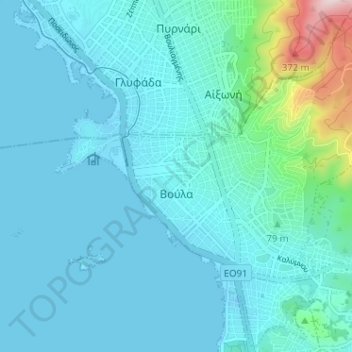
Name: Topografische Karte Municipal Unit of Voula, Höhe, Relief.
Durchschnittliche Höhe: 57 m
Minimale Höhe: -12 m
Maximale Höhe: 476 m
Andere topografische Karten
Klicken Sie auf eine Karte, um ihre Topografie, ihre Höhe und ihr Relief anzuzeigen.
Chamolia
Greece > Attica > Regional Unit of East Attica
Chamolia, Municipality of Markopoulo Mesogaias, Regional Unit of East Attica, Attica, 190 03, Greece
Durchschnittliche Höhe: 45 m
Municipality of Acharnes
Greece > Attica > Regional Unit of East Attica
Municipality of Acharnes, Regional Unit of East Attica, Attica, Greece
Durchschnittliche Höhe: 498 m
Rafina
Greece > Attica > Regional Unit of East Attica > Rafina Municipal Unit
Rafina, Rafina Municipal Unit, Municipality of Rafina - Pikermi, Regional Unit of East Attica, Attica, 190 09, Greece
Durchschnittliche Höhe: 44 m
Astypalaia
Greece > Attica > Regional Unit of East Attica > Anavissos Municipal Unit
Astypalaia, Anavissos Municipal Unit, Municipality of Saronikos, Regional Unit of East Attica, Attica, 190 13, Greece
Durchschnittliche Höhe: 10 m
Ανάβυσσος
Greece > Attica > Regional Unit of East Attica > Anavissos Municipal Unit
Ανάβυσσος, Anavissos Municipal Unit, Municipality of Saronikos, Regional Unit of East Attica, Attica, 190 13, Greece
Durchschnittliche Höhe: 91 m
Koropi
Greece > Attica > Regional Unit of East Attica
Koropi, Municipality of Kropia, Regional Unit of East Attica, Attica, 194 00, Greece
Durchschnittliche Höhe: 148 m
Nea Makri Municipal Unit
Greece > Attica > Regional Unit of East Attica
Nea Makri Municipal Unit, Municipality of Marathonas, Regional Unit of East Attica, Attica, 190 05, Greece
Durchschnittliche Höhe: 217 m
Christoupoli
Greece > Attica > Regional Unit of East Attica > Spata-Loutsa Municipal Unit
Christoupoli, Spata-Loutsa Community, Spata-Loutsa Municipal Unit, Municipality of Spata - Artemida, Regional Unit of East Attica, Attica, 190 04, Greece
Durchschnittliche Höhe: 122 m
Limenas Markopoulou
Greece > Attica > Regional Unit of East Attica
Limenas Markopoulou, Municipality of Markopoulo Mesogaias, Regional Unit of East Attica, Attica, 190 23, Greece
Durchschnittliche Höhe: 93 m
Glyka Nera Municipal Unit
Greece > Attica > Regional Unit of East Attica
Glyka Nera Municipal Unit, Municipality of Paiania, Regional Unit of East Attica, Attica, 153 54, Greece
Durchschnittliche Höhe: 309 m
Artemida
Greece > Attica > Regional Unit of East Attica > Artemida Municipal Unit
Artemida, Artemida Municipal Unit, Municipality of Spata - Artemida, Regional Unit of East Attica, Attica, 190 16, Greece
Durchschnittliche Höhe: 38 m
Municipality of Lavreotiki
Greece > Attica > Regional Unit of East Attica
Municipality of Lavreotiki, Regional Unit of East Attica, Attica, Greece
Durchschnittliche Höhe: 80 m
Gerakas Municipal Unit
Greece > Attica > Regional Unit of East Attica
Gerakas Municipal Unit, Municipality of Pallini, Regional Unit of East Attica, Attica, 153 44, Greece
Durchschnittliche Höhe: 259 m
Vouliagmeni Municipal Unit
Greece > Attica > Regional Unit of East Attica
Vouliagmeni Municipal Unit, Municipality of Vari - Voula - Vouliagmeni, Regional Unit of East Attica, Attica, 166 71, Greece
Durchschnittliche Höhe: 20 m
Pikermi Municipal Unit
Greece > Attica > Regional Unit of East Attica > Pikermi Municipal Unit
Pikermi Municipal Unit, Municipality of Rafina - Pikermi, Regional Unit of East Attica, Attica, Greece
Durchschnittliche Höhe: 227 m
Anavissos Municipal Unit
Greece > Attica > Regional Unit of East Attica
Anavissos Municipal Unit, Municipality of Saronikos, Regional Unit of East Attica, Attica, Greece
Durchschnittliche Höhe: 60 m
Mount Parnitha National Park
Greece > Attica > Regional Unit of East Attica
Mount Parnitha National Park, Regional Unit of East Attica, Attica, Greece
Durchschnittliche Höhe: 543 m
Marathon
Greece > Attica > Regional Unit of East Attica
Marathon, Municipality of Marathonas, Regional Unit of East Attica, Attica, 190 07, Greece
Durchschnittliche Höhe: 146 m