
Spenden
Rüste dich für dein nächstes Abenteuer:
Als Amazon-Partner verdient diese Seite an qualifizierten Käufen, ohne dass Ihnen zusätzliche Kosten entstehen.
Topografische Karte Bilkhawthlir
Klicken Sie auf die Karte, um die Höhe anzuzeigen.
Spenden
Rüste dich für dein nächstes Abenteuer:
Als Amazon-Partner verdient diese Seite an qualifizierten Käufen, ohne dass Ihnen zusätzliche Kosten entstehen.
Über diese Karte
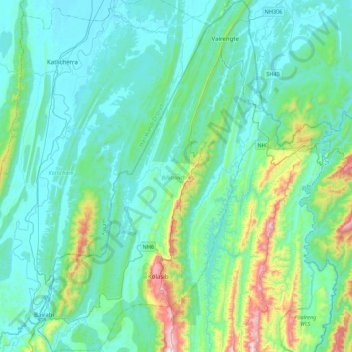
Name: Topografische Karte Bilkhawthlir, Höhe, Relief.
Ort: Bilkhawthlir, Kolasib, Mizoram, India (24.14080 92.52774 24.52313 92.89288)
Durchschnittliche Höhe: 158 m
Minimale Höhe: 22 m
Maximale Höhe: 813 m
Spenden
Rüste dich für dein nächstes Abenteuer:
Als Amazon-Partner verdient diese Seite an qualifizierten Käufen, ohne dass Ihnen zusätzliche Kosten entstehen.
Andere topografische Karten
Klicken Sie auf eine Karte, um ihre Topografie, ihre Höhe und ihr Relief anzuzeigen.
Aizawl
Aizawl has a mild, sub-tropical climate due to its location and elevation. Under the Köppen climate classification, Aizawl features a humid subtropical climate (Cwa). In summer, temperatures are moderately warm, averaging around 20–30 °C (68–86 °F). In winter, daytime temperatures are cooler in…
Durchschnittliche Höhe: 556 m
Spenden
Rüste dich für dein nächstes Abenteuer:
Als Amazon-Partner verdient diese Seite an qualifizierten Käufen, ohne dass Ihnen zusätzliche Kosten entstehen.
Spenden
Rüste dich für dein nächstes Abenteuer:
Als Amazon-Partner verdient diese Seite an qualifizierten Käufen, ohne dass Ihnen zusätzliche Kosten entstehen.
Aizawl
Aizawl (English: /ˈaɪzɔːl/ EYE-zawl; Mizo: [ˈaɪ̯.ˈzɔːl] ), formerly known as Aijal, is the capital city and the most populous city of Mizoram, India. It is also the third largest city in northeast India. It is situated atop a series of ridges, with an average elevation of around 1,132 metres (3,714…
Durchschnittliche Höhe: 562 m
Spenden
Rüste dich für dein nächstes Abenteuer:
Als Amazon-Partner verdient diese Seite an qualifizierten Käufen, ohne dass Ihnen zusätzliche Kosten entstehen.
Aizawl
Aizawl (English: /aɪˈzɔːl/; Mizo: [ˈaɪ̯.ˈzɔːl] ), formerly known as Aijal, is the capital city and the most populous city of Mizoram, India. It is also the third largest city in northeast India, after Guwahati and Agartala. It is situated atop a series of ridges, with an average elevation of around…
Durchschnittliche Höhe: 562 m