
Topografische Karte Tagus
Interaktive Karte
Klicken Sie auf die Karte, um die Höhe anzuzeigen.
Über diese Karte
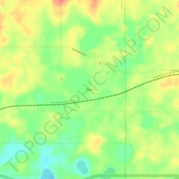
Name: Topografische Karte Tagus, Höhe, Relief.
Ort: Tagus, Mountrail County, North Dakota, United States (48.32640 -101.95405 48.36640 -101.91405)
Durchschnittliche Höhe: 671 m
Minimale Höhe: 643 m
Maximale Höhe: 699 m
Andere topografische Karten
Klicken Sie auf eine Karte, um ihre Topografie, ihre Höhe und ihr Relief anzuzeigen.
Palermo Wildlife Management Area
United States > North Dakota > Mountrail County > Stanley > Palermo
Palermo Wildlife Management Area, US 2, Palermo, Stanley, Mountrail County, North Dakota, 58769, United States
Durchschnittliche Höhe: 655 m
Stanley
United States > North Dakota > Mountrail County > Stanley
Stanley, Mountrail County, North Dakota, United States
Durchschnittliche Höhe: 684 m