
Topografische Karte Walley
Interaktive Karte
Klicken Sie auf die Karte, um die Höhe anzuzeigen.
Über diese Karte
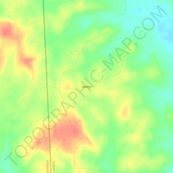
Name: Topografische Karte Walley, Höhe, Relief.
Ort: Walley, Washington County, Alabama, United States (31.16462 -88.44502 31.20462 -88.40502)
Durchschnittliche Höhe: 73 m
Minimale Höhe: 45 m
Maximale Höhe: 103 m
Andere topografische Karten
Klicken Sie auf eine Karte, um ihre Topografie, ihre Höhe und ihr Relief anzuzeigen.
Chatom
United States > Alabama > Washington County
Chatom, Washington County, Alabama, 36518, United States
Durchschnittliche Höhe: 48 m
Deer Park
United States > Alabama > Washington County
Deer Park, Washington County, Alabama, United States
Durchschnittliche Höhe: 48 m
Tibbie
United States > Alabama > Washington County > Tibbie
Tibbie, Washington County, Alabama, 36583, United States
Durchschnittliche Höhe: 55 m
McIntosh
United States > Alabama > Washington County > McIntosh
McIntosh, Washington County, Alabama, United States
Durchschnittliche Höhe: 13 m
Carson
United States > Alabama > Washington County
Carson, Washington County, Alabama, 36548, United States
Durchschnittliche Höhe: 18 m