
Topografische Karte Sivas
Interaktive Karte
Klicken Sie auf die Karte, um die Höhe anzuzeigen.
Über diese Karte
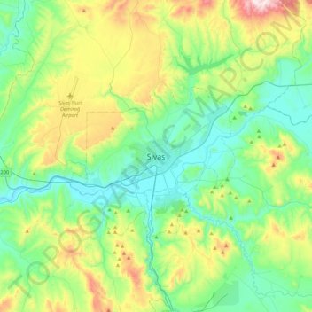
Name: Topografische Karte Sivas, Höhe, Relief.
Durchschnittliche Höhe: 1’455 m
Minimale Höhe: 1’244 m
Maximale Höhe: 2’018 m
The city, which lies at an elevation of 1,278 metres (4,193 ft) in the broad valley of the Kızılırmak river, is a moderately-sized trade center and industrial city, although the economy has traditionally been based on agriculture. Rail repair shops and a thriving manufacturing industry of rugs, bricks, cement, and cotton and woolen textiles form the mainstays of the city's economy. The surrounding region is a cereal-producing area with large deposits of iron ore which are worked at Divriği.