
Topografische Karte Vittoria
Interaktive Karte
Klicken Sie auf die Karte, um die Höhe anzuzeigen.
Vittoria
The town was founded on a very fertile valley known as "Boscopiano". On the south of the city there is the "natural reserve of Aleppo pines" (Riserva naturale del Pino d'Aleppo). The coastlines along the sea are low and sandy with rare rocks. The highest point, though poorly mountainous, is Mount Calvo (250 meters). Vittoria is located between the municipalities of Acate and Ragusa, while the hillside is bordered by the towns of Comiso and Chiaramonte Gulfi. It is located 27 km from Ragusa and Gela, 108 km from Siracusa and 131 km from Catania. Vittoria has an altitude of 168 meters s.l.m. and an area of 181.31 km². Its only hamlet (frazione) is the seaside locality of Scoglitti. However, in addition to the urban area, it has 45 different contrade.
Über diese Karte
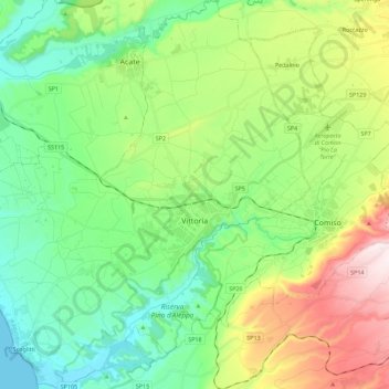
Name: Topografische Karte Vittoria, Höhe, Relief.
Ort: Vittoria, Ragusa, Sicily, 97019, Italy (36.87376 14.38772 37.05345 14.59738)
Durchschnittliche Höhe: 194 m
Minimale Höhe: 0 m
Maximale Höhe: 618 m