
Topografische Karte Saint-Aubin-Château-Neuf
Interaktive Karte
Klicken Sie auf die Karte, um die Höhe anzuzeigen.
Über diese Karte
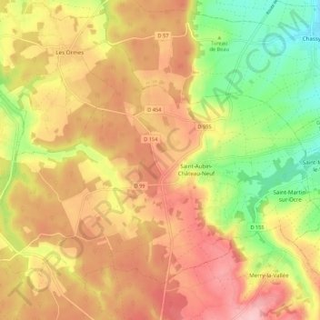
Name: Topografische Karte Saint-Aubin-Château-Neuf, Höhe, Relief.
Durchschnittliche Höhe: 211 m
Minimale Höhe: 119 m
Maximale Höhe: 287 m
Saint-Aubin-Château-Neuf est situé dans l'Yonne, avec Auxerre à 22 kilomètres à l'est et Toucy à 10 km au sud. Paris est à 155 km. La commune appartient au canton d'Aillant-sur-Tholon et à l'arrondissement d'Auxerre. Sa superficie est de 25 km2 et son altitude moyenne de environ 200 mètres.
Andere topografische Karten
Klicken Sie auf eine Karte, um ihre Topografie, ihre Höhe und ihr Relief anzuzeigen.
D 955
France > Bourgogne-Franche-Comté > Yonne > Le Val d'Ocre
D 955, Beaurain, Saint-Aubin-Château-Neuf, Le Val d'Ocre, Auxerre, Yonne, Bourgogne-Franche-Comté, France métropolitaine, 89110, France
Durchschnittliche Höhe: 236 m
Lampy
France > Bourgogne-Franche-Comté > Yonne > Le Val d'Ocre
Lampy, Saint-Aubin-Château-Neuf, Le Val d'Ocre, Auxerre, Yonne, Bourgogne-Franche-Comté, France métropolitaine, 89110, France
Durchschnittliche Höhe: 207 m