
Spenden
Rüste dich für dein nächstes Abenteuer:
Als Amazon-Partner verdient diese Seite an qualifizierten Käufen, ohne dass Ihnen zusätzliche Kosten entstehen.
Topografische Karte Stockbridge
Klicken Sie auf die Karte, um die Höhe anzuzeigen.
Spenden
Rüste dich für dein nächstes Abenteuer:
Als Amazon-Partner verdient diese Seite an qualifizierten Käufen, ohne dass Ihnen zusätzliche Kosten entstehen.
Über diese Karte
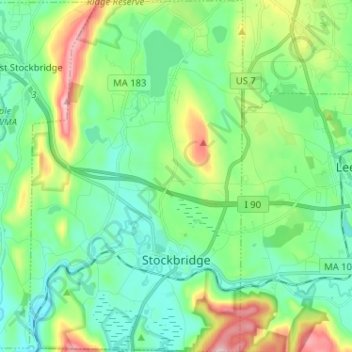
Name: Topografische Karte Stockbridge, Höhe, Relief.
Ort: Stockbridge, Berkshire County, Massachusetts, United States (42.25750 -73.36593 42.35234 -73.28814)
Durchschnittliche Höhe: 316 m
Minimale Höhe: 228 m
Maximale Höhe: 557 m
Spenden
Rüste dich für dein nächstes Abenteuer:
Als Amazon-Partner verdient diese Seite an qualifizierten Käufen, ohne dass Ihnen zusätzliche Kosten entstehen.
Andere topografische Karten
Klicken Sie auf eine Karte, um ihre Topografie, ihre Höhe und ihr Relief anzuzeigen.
Mount Greylock
United States > Massachusetts > Berkshire County > Adams
Northern hardwood forest characterize lower and mid-elevations, while upper slopes are covered with balsam fir and red spruce as well as American mountain ash. About 555 acres (225 hectares) of old growth forest have been inventoried within the Greylock Range, including tree specimens up to 350 years old. On…
Durchschnittliche Höhe: 746 m
Berkshire Heights
United States > Massachusetts > Berkshire County > Great Barrington
Durchschnittliche Höhe: 243 m
Eastern Summit
United States > Massachusetts > Berkshire County > Florida
Durchschnittliche Höhe: 510 m
Mount Everett
United States > Massachusetts > Berkshire County
Mount Everett helps divide the watersheds of the Hudson and Housatonic rivers. Its eastern slopes share a larger escarpment with Mount Race and Bear Mountain plus several related summits. This escarpment rises from an elevation around 700 feet in Sheffield's Housatonic Valley at a mean angle of about 20…
Durchschnittliche Höhe: 561 m
Spenden
Rüste dich für dein nächstes Abenteuer:
Als Amazon-Partner verdient diese Seite an qualifizierten Käufen, ohne dass Ihnen zusätzliche Kosten entstehen.
Hephzibah Heights
United States > Massachusetts > Berkshire County > Monterey
Durchschnittliche Höhe: 457 m
Mount Greylock
United States > Massachusetts > Berkshire County > Adams
Geographically, Mount Greylock is part of an 11-mile-long (18 km) by 4+1⁄2-mile-wide (7 km) island-like range that runs north-south between the Hoosac Range to the east, the Green Mountains to the north, the Berkshires to both the south and east, and the Taconic Mountains to the west with which it is…
Durchschnittliche Höhe: 746 m
Southfield
United States > Massachusetts > Berkshire County > New Marlborough
Durchschnittliche Höhe: 405 m
Spenden
Rüste dich für dein nächstes Abenteuer:
Als Amazon-Partner verdient diese Seite an qualifizierten Käufen, ohne dass Ihnen zusätzliche Kosten entstehen.
Brayton Hill
United States > Massachusetts > Berkshire County > North Adams
Durchschnittliche Höhe: 321 m
State Line
United States > Massachusetts > Berkshire County > West Stockbridge
Durchschnittliche Höhe: 344 m
Becket Mountain
United States > Massachusetts > Berkshire County > Becket
Durchschnittliche Höhe: 562 m
Spenden
Rüste dich für dein nächstes Abenteuer:
Als Amazon-Partner verdient diese Seite an qualifizierten Käufen, ohne dass Ihnen zusätzliche Kosten entstehen.
Yankee Orchards
United States > Massachusetts > Berkshire County > Pittsfield
Durchschnittliche Höhe: 344 m
Pittsfield
United States > Massachusetts > Berkshire County
Pittsfield has a humid continental climate (Dfb). Winters are harsh due the city's high elevation at 1,039 ft (317 m), with an average annual snowfall of 75.9 inches (1,930 mm) and temperatures dipping to 0 °F (−18 °C) or colder 13 times per year. Summers, however, are typically warm and pleasant, with…
Durchschnittliche Höhe: 433 m
Coltsville
United States > Massachusetts > Berkshire County > Pittsfield
Durchschnittliche Höhe: 332 m
Clover Hill Farm Conservation Area
United States > Massachusetts > Berkshire County > Williamstown > Meadowvale
Durchschnittliche Höhe: 217 m
Spenden
Rüste dich für dein nächstes Abenteuer:
Als Amazon-Partner verdient diese Seite an qualifizierten Käufen, ohne dass Ihnen zusätzliche Kosten entstehen.
Bonny Rigg Corners
United States > Massachusetts > Berkshire County > Becket
Durchschnittliche Höhe: 450 m
Risingdale
United States > Massachusetts > Berkshire County > Great Barrington
Durchschnittliche Höhe: 277 m
Brookside
United States > Massachusetts > Berkshire County > Great Barrington
Durchschnittliche Höhe: 284 m
Spenden
Rüste dich für dein nächstes Abenteuer:
Als Amazon-Partner verdient diese Seite an qualifizierten Käufen, ohne dass Ihnen zusätzliche Kosten entstehen.
Richmond Pond
United States > Massachusetts > Berkshire County > Richmond > Camp Russell
Durchschnittliche Höhe: 353 m
March Cataract Falls
United States > Massachusetts > Berkshire County > Williamstown
Durchschnittliche Höhe: 765 m
Greylock
United States > Massachusetts > Berkshire County > North Adams > Greylock
Durchschnittliche Höhe: 314 m
Camp Russell
United States > Massachusetts > Berkshire County > Pittsfield
Durchschnittliche Höhe: 380 m
Spenden
Rüste dich für dein nächstes Abenteuer:
Als Amazon-Partner verdient diese Seite an qualifizierten Käufen, ohne dass Ihnen zusätzliche Kosten entstehen.
Pine Cobble
United States > Massachusetts > Berkshire County > Williamstown
Durchschnittliche Höhe: 426 m
Mountain Meadow Preserve
United States > Massachusetts > Berkshire County > Williamstown
Durchschnittliche Höhe: 267 m
Housatonic
United States > Massachusetts > Berkshire County > Great Barrington
Durchschnittliche Höhe: 291 m
Spenden
Rüste dich für dein nächstes Abenteuer:
Als Amazon-Partner verdient diese Seite an qualifizierten Käufen, ohne dass Ihnen zusätzliche Kosten entstehen.
Mount Frissell
United States > Massachusetts > Berkshire County > Mount Washington
Durchschnittliche Höhe: 614 m