
Topografische Karte Point Washington
Klicken Sie auf die Karte, um die Höhe anzuzeigen.
Über diese Karte
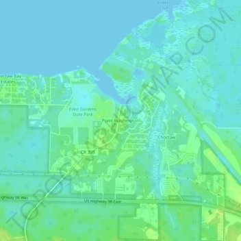
Name: Topografische Karte Point Washington, Höhe, Relief.
Ort: Point Washington, Walton County, Florida, United States (30.35020 -86.13494 30.39020 -86.09494)
Durchschnittliche Höhe: 4 m
Minimale Höhe: -2 m
Maximale Höhe: 13 m
Andere topografische Karten
Klicken Sie auf eine Karte, um ihre Topografie, ihre Höhe und ihr Relief anzuzeigen.
Paxton
United States > Florida > Walton County
Paxton is a town in Walton County, Florida, United States. The population was 644 as of the 2010 census. Located near Britton Hill on the Alabama–Florida state line, the town has the highest elevation of any in Florida.
Durchschnittliche Höhe: 82 m
Paxton
United States > Florida > Walton County
Paxton is a town in Walton County, Florida, United States. Located near Britton Hill on the Alabama–Florida state line, it has the highest elevation of any in Florida. The Town of Paxton is located on the Florida Panhandle, and is part of the Crestview–Fort Walton Beach–Destin, Florida Metropolitan…
Durchschnittliche Höhe: 82 m
Choctaw Beach Community Center Park
United States > Florida > Walton County > Freeport > Choctaw Beach
Durchschnittliche Höhe: 7 m