
Topografische Karte Acamixtla
Interaktive Karte
Klicken Sie auf die Karte, um die Höhe anzuzeigen.
Über diese Karte
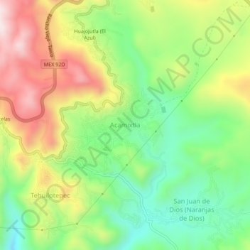
Name: Topografische Karte Acamixtla, Höhe, Relief.
Ort: Acamixtla, Taxco de Alarcón, Guerrero, 40211, México (18.54401 -99.58625 18.58401 -99.54625)
Durchschnittliche Höhe: 1’647 m
Minimale Höhe: 1’419 m
Maximale Höhe: 1’950 m
Andere topografische Karten
Klicken Sie auf eine Karte, um ihre Topografie, ihre Höhe und ihr Relief anzuzeigen.
Taxco
México > Guerrero > Taxco de Alarcón
Taxco, Taxco de Alarcón, Guerrero, 40200, México
Durchschnittliche Höhe: 1’792 m
Taxco el Viejo
México > Guerrero > Taxco de Alarcón
Taxco el Viejo, Taxco de Alarcón, Guerrero, México
Durchschnittliche Höhe: 1’362 m
Mil Cascadas (Las Granadas)
México > Guerrero > Taxco de Alarcón > Zacapalco
Mil Cascadas (Las Granadas), Rancho Viejo - Taxco, Zacapalco, Taxco de Alarcón, Guerrero, 40000, México
Durchschnittliche Höhe: 1’522 m
Coamazac
México > Guerrero > Taxco de Alarcón > Coamazac
Coamazac, Taxco de Alarcón, Guerrero, México
Durchschnittliche Höhe: 1’124 m
Acuitlapán
México > Guerrero > Taxco de Alarcón > Acuitlapán
Acuitlapán, Taxco de Alarcón, Guerrero, México
Durchschnittliche Höhe: 1’593 m
Teacalco
México > Guerrero > Taxco de Alarcón
Teacalco, Taxco de Alarcón, Guerrero, 62640, México
Durchschnittliche Höhe: 1’063 m