
Topografische Karte Map Kha Phatthana
Interaktive Karte
Klicken Sie auf die Karte, um die Höhe anzuzeigen.
Über diese Karte
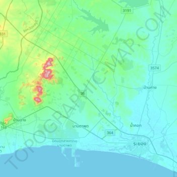
Name: Topografische Karte Map Kha Phatthana, Höhe, Relief.
Ort: Map Kha Phatthana, Rayong Province, Thailand (12.62137 101.02318 12.94137 101.34318)
Durchschnittliche Höhe: 50 m
Minimale Höhe: -3 m
Maximale Höhe: 408 m
Andere topografische Karten
Klicken Sie auf eine Karte, um ihre Topografie, ihre Höhe und ihr Relief anzuzeigen.
Rayong
Rayong, Choeng Noen, Rayong Province, 21000, Thailand
Durchschnittliche Höhe: 31 m
Ban Chang
Ban Chang, Rayong Province, 21130, Thailand
Durchschnittliche Höhe: 32 m
Chom Phon Chao Phraya
Thailand > Rayong Province > Chom Phon Chao Phraya
Chom Phon Chao Phraya, Rayong Province, Thailand
Durchschnittliche Höhe: 89 m
Klaeng
Klaeng, Ban Na, Rayong Province, Thailand
Durchschnittliche Höhe: 9 m
Pluak Daeng
Thailand > Rayong Province > Pluak Daeng
Pluak Daeng, Rayong Province, Thailand
Durchschnittliche Höhe: 67 m
Ban Phe
Thailand > Rayong Province > Ban Phe
Ban Phe, Rayong Province, 21160, Thailand
Durchschnittliche Höhe: 15 m
Lan Hin Khao Beach
Thailand > Rayong Province > Lan Hin Khao Beach
Lan Hin Khao Beach, Rayong Province, Thailand
Durchschnittliche Höhe: 5 m
Ban Chang
Thailand > Rayong Province > Ban Chang
Ban Chang, Rayong Province, TUNG PONG, Thailand
Durchschnittliche Höhe: 58 m
Ban Pak Don
Thailand > Rayong Province > Ban Pak Don
Ban Pak Don, Rayong Province, 21190, Thailand
Durchschnittliche Höhe: 11 m