
Topografische Karte Acerno
Klicken Sie auf die Karte, um die Höhe anzuzeigen.
Acerno
The communal territory has an elevation varying between 400 and 1790 metres above sea level. Outside of the town itself it is entirely uninhabited by humans: there are no satellite hamlets or even scattered dwellings under permanent habitation. It is rich in flora, however, with forests of maple, oak, chestnut, hazel, beech and alder, while the fauna includes golden eagles, dormice, wild cats, otters and wolves.
Über diese Karte
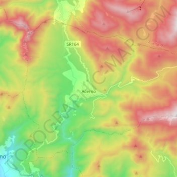
Name: Topografische Karte Acerno, Höhe, Relief.
Ort: Acerno, Salerno, Campania, 84042, Italy (40.69710 15.00360 40.78177 15.14572)
Durchschnittliche Höhe: 954 m
Minimale Höhe: 241 m
Maximale Höhe: 1’778 m
Andere topografische Karten
Klicken Sie auf eine Karte, um ihre Topografie, ihre Höhe und ihr Relief anzuzeigen.