
Topografische Karte Marbella
Interaktive Karte
Klicken Sie auf die Karte, um die Höhe anzuzeigen.
Über diese Karte
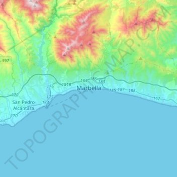
Name: Topografische Karte Marbella, Höhe, Relief.
Ort: Marbella, Costa del Sol Occidental, Malaga, Andalusia, Spain (36.46001 -5.01467 36.55497 -4.73057)
Durchschnittliche Höhe: 216 m
Minimale Höhe: -1 m
Maximale Höhe: 1’319 m
There are five geomorphological units: the Sierra Blanca, the Sierra Blanca piedmont (foothills), the lower hill country, the plains and the coastal dunes. The Sierra Blanca is most centrally located in the province, looming over the old village. This mountain range has three peaks: La Concha, located further west at 1,215 m (3,986 feet) above sea level, Juanar Cross, located eastward (within the municipality of Ojen) at 1,178 m (3,865 feet) above sea level, and the highest, Mount Lastonar, located between the two at 1,270 m (4,170 feet). Marbella's topography is characterised by extensive coastal plains formed from eroded mountains. North of the plain, is an area of elevations from 100 and 400 m (330 and 1,300 feet), occupied by low hills, with foothills and steeper slopes of the mountains behind. The coast is generally low and has sandy beaches that are more extensive further east, between the fishing port and Cabopino. Despite the intense urbanisation of the coast, it still retains a natural area of dunes, the Artola Dunes (Dunas de Artola), at the eastern end of town.
Andere topografische Karten
Klicken Sie auf eine Karte, um ihre Topografie, ihre Höhe und ihr Relief anzuzeigen.
Estepona
Spain > Andalusia > Costa del Sol Occidental
Estepona, Costa del Sol Occidental, Malaga, Andalusia, Spain
Durchschnittliche Höhe: 265 m
Mijas
Spain > Andalusia > Costa del Sol Occidental
Mijas, Costa del Sol Occidental, Malaga, Andalusia, Spain
Durchschnittliche Höhe: 171 m
Sierra Bermeja
Spain > Andalusia > Costa del Sol Occidental > Casares
Sierra Bermeja, Casares, Costa del Sol Occidental, Malaga, Andalusia, Spain
Durchschnittliche Höhe: 1’084 m
Torremolinos
Spain > Andalusia > Costa del Sol Occidental > Torremolinos
Torremolinos, Costa del Sol Occidental, Malaga, Andalusia, Spain
Durchschnittliche Höhe: 85 m
Puerto de la Cruz
Spain > Andalusia > Costa del Sol Occidental > Casares
Puerto de la Cruz, Casares, Costa del Sol Occidental, Malaga, Andalusia, 29690, Spain
Durchschnittliche Höhe: 369 m
Sierra Palmitera
Spain > Andalusia > Costa del Sol Occidental > Benahavís
Sierra Palmitera, Benahavís, Costa del Sol Occidental, Malaga, Andalusia, Spain
Durchschnittliche Höhe: 806 m
Fuengirola
Spain > Andalusia > Costa del Sol Occidental
Fuengirola, Costa del Sol Occidental, Malaga, Andalusia, 29640, Spain
Durchschnittliche Höhe: 59 m
San Pedro de Alcántara
Spain > Andalusia > Costa del Sol Occidental > Marbella
San Pedro de Alcántara, Marbella, Costa del Sol Occidental, Malaga, Andalusia, 29670, Spain
Durchschnittliche Höhe: 29 m
Benahavís
Spain > Andalusia > Costa del Sol Occidental
Benahavís, Costa del Sol Occidental, Malaga, Andalusia, 29679, Spain
Durchschnittliche Höhe: 484 m
Casares del Sol
Spain > Andalusia > Costa del Sol Occidental > Casares > Casares del Sol
Casares del Sol, Casares, Costa del Sol Occidental, Malaga, Andalusia, 29693, Spain
Durchschnittliche Höhe: 41 m
Urbanizacion Playa Mijas
Spain > Andalusia > Costa del Sol Occidental > Urbanización Chaparral > Urbanizacion Playa Mijas
Urbanizacion Playa Mijas, Urbanización Chaparral, Mijas, Costa del Sol Occidental, Malaga, Andalusia, 29648, Spain
Durchschnittliche Höhe: 27 m
Casares
Spain > Andalusia > Costa del Sol Occidental
Casares, Costa del Sol Occidental, Malaga, Andalusia, 29690, Spain
Durchschnittliche Höhe: 224 m
Benalmádena
Spain > Andalusia > Costa del Sol Occidental
Benalmádena, Costa del Sol Occidental, Malaga, Andalusia, Spain
Durchschnittliche Höhe: 276 m