
Topografische Karte Helvellyn
Klicken Sie auf die Karte, um die Höhe anzuzeigen.
Helvellyn
Red Tarn, a classic corrie tarn, is a high-elevation tarn with low nutrient levels and poor in the number of species it supports. Characteristic vegetation zones include a water-starwort (Callitriche) in shallower areas and the alga Nitella flexilis in deeper water and around the inlet. Other species include a pondweed (Potamogeton) which grows in 2–3 m (7–10 ft) of water and the rush Juncus bulbosus. Brown trout and schelly, a species of whitefish, are found in the tarn.
Über diese Karte
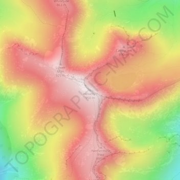
Name: Topografische Karte Helvellyn, Höhe, Relief.
Durchschnittliche Höhe: 680 m
Minimale Höhe: 277 m
Maximale Höhe: 943 m
Andere topografische Karten
Klicken Sie auf eine Karte, um ihre Topografie, ihre Höhe und ihr Relief anzuzeigen.
Brown Cove Tarn
United Kingdom > England > Westmorland and Furness > Patterdale
Durchschnittliche Höhe: 699 m
Hard Tarn
United Kingdom > England > Westmorland and Furness > Patterdale
Durchschnittliche Höhe: 630 m
Brothers Water
United Kingdom > England > Westmorland and Furness > Patterdale > Hartsop
Durchschnittliche Höhe: 298 m
Norfolk Isle
United Kingdom > England > Westmorland and Furness > Patterdale
Durchschnittliche Höhe: 260 m