
Topografische Karte Schultz Creek
Interaktive Karte
Klicken Sie auf die Karte, um die Höhe anzuzeigen.
Über diese Karte
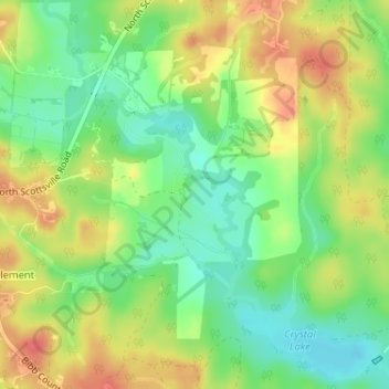
Name: Topografische Karte Schultz Creek, Höhe, Relief.
Ort: Schultz Creek, Bibb County, Alabama, United States (33.07063 -87.24235 33.08686 -87.22803)
Durchschnittliche Höhe: 115 m
Minimale Höhe: 87 m
Maximale Höhe: 146 m
Andere topografische Karten
Klicken Sie auf eine Karte, um ihre Topografie, ihre Höhe und ihr Relief anzuzeigen.
East Centreville
United States > Alabama > Bibb County > Centreville
East Centreville, Centreville, Bibb County, Alabama, 35042, United States
Durchschnittliche Höhe: 77 m
Lawley
United States > Alabama > Bibb County
Lawley, Bibb County, Alabama, 35793, United States
Durchschnittliche Höhe: 139 m
Fountain Hill
United States > Alabama > Bibb County
Fountain Hill, Bibb County, Alabama, United States
Durchschnittliche Höhe: 166 m
Centreville
United States > Alabama > Bibb County
Centreville, Bibb County, Alabama, 35042, United States
Durchschnittliche Höhe: 93 m
Tucker
United States > Alabama > Bibb County > Tucker
Tucker, Bibb County, Alabama, United States
Durchschnittliche Höhe: 150 m
Randolph
United States > Alabama > Bibb County > Randolph
Randolph, Bibb County, Alabama, United States
Durchschnittliche Höhe: 162 m
Sand Mountain
United States > Alabama > Bibb County
Sand Mountain, Bibb County, Alabama, United States
Durchschnittliche Höhe: 156 m
Brent
United States > Alabama > Bibb County > Brent
Brent, Bibb County, Alabama, 35034, United States
Durchschnittliche Höhe: 84 m